:quality(70)/cloudfront-us-east-1.images.arcpublishing.com/cmg/WW5AJL3ARQUGDQMAQUNSFX4CLE.jpg)
Jacksonville, Fl. — The “Buresh Bottom Line”: Always be prepared!.....First Alert Hurricane Survival Guide... City of Jacksonville Preparedness Guide... Georgia Hurricane Guide.
STAY INFORMED: Get the * FREE * First Alert Weather app
FREE NEWS UPDATES, ALERTS: Action News Jax app for Apple | For Android
WATCH “Talking & Tracking the Tropics: The Science Behind the Season”
WATCH “Preparing for the Storm”
READ the First Alert Hurricane Center “Survival Guide”
***** ALWAYS CHECK & RE-CHECK THE LATEST FORECAST & UPDATES! *****
The Caribbean/Gulf of Mexico & SW Atlantic will remain the areas to keep an eye on over the next couple of weeks (climatologically favored too).
Areas to Watch:
(1) low pressure over the Central Atlantic evolved from an upper low, became t.d. #27 Mon. morning & then to tropical storm Epsilon within a few hours - the fastest to the 27th storm breaking the record set in - of course - 2005.... & became a hurricane Tue. strengthening into a Cat. 3 Wed. before leveling off again as a Cat. 2. Epsilon is turning more northward sparing Bermuda a direct hit before turning northeast & accelerating by the weekend over the N. Atlantic. While the core of the hurricane misses Bermuda, strong winds & rough seas/surf will still affect the island through the end of the week. Easterly swells will enhance rough surf & the rip current risk for the Bahamas, Florida & much of the U.S. east coast.
(2) There continue to be hints of low pressure developing near Fl. over the weekend/early next week then. An inverted surface trough (“band” of lower pressures creating convergence) is evident near Fl. through the weekend which can sometimes lead to low pressure then tropical development, especially late in the season. The UKMET is most emphatic but also fastest in taking the low well east of Fl. next week. The Euro is slower & generally weak. The GFS model simply shows an inverted trough with no surface low pressure developing.
Satellite below shows disorganized showers & t’storms over the Bahamas, Fl. Straits & Caribbean... Epsilon over the Central Atlantic far to the southeast of Bermuda... & several tropical waves over the Eastern Atlantic at a low latitude but which have little chance to make it all the way across the Atlantic....


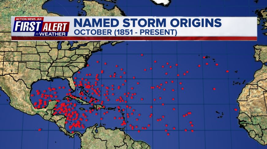
October tropical cyclone origin points are clustered over the Caribbean, Gulf of Mexico & SW Atlantic:
Atlantic Basin wave forecast for 24, 48 & 72 hours respectively:


:quality(70)/cloudfront-us-east-1.images.arcpublishing.com/cmg/HJ3L3HBBJBH6PB5ZFB3SVGFXSU.png)
:quality(70)/cloudfront-us-east-1.images.arcpublishing.com/cmg/4TQDXERT5VGORNZ4NQWXNO5H64.png)
:quality(70)/cloudfront-us-east-1.images.arcpublishing.com/cmg/SKX4RKW645ERTATCLA4V2FVRKQ.png)
:quality(70)/cloudfront-us-east-1.images.arcpublishing.com/cmg/TYVIYUNT7BBHDLGYYWGCJB424E.png)
:quality(70)/cloudfront-us-east-1.images.arcpublishing.com/cmg/WYUHBF3SFRC7HITANNA24VG6DI.jpg)
:quality(70)/cloudfront-us-east-1.images.arcpublishing.com/cmg/V7JDMMD6JJEEHIL6C7OSLV3ABU.png)
:quality(70)/cloudfront-us-east-1.images.arcpublishing.com/cmg/B3QLY3JLBRENWEUKC3MQBGTT2A.jpg)
:quality(70)/cloudfront-us-east-1.images.arcpublishing.com/cmg/KQMV5IYHCVQZVZFINXLNF2ODVM.jpg)
:quality(70)/cloudfront-us-east-1.images.arcpublishing.com/cmg/I5EFEKL5DTS2THVMUT33QWODRY.jpg)
 Sign Up

