:quality(70)/cloudfront-us-east-1.images.arcpublishing.com/cmg/WW5AJL3ARQUGDQMAQUNSFX4CLE.jpg)
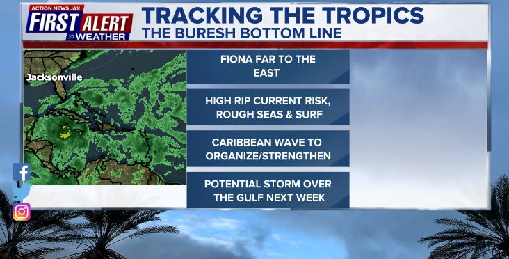
Jacksonville, Fl. — The “Buresh Bottom Line”: Always be prepared!.....First Alert Hurricane Survival Guide... City of Jacksonville Preparedness Guide... Georgia Hurricane Guide.
STAY INFORMED: Get the * FREE * First Alert Weather app
FREE NEWS UPDATES, ALERTS: Action News Jax app for Apple | For Android
WATCH “Preparing for the Storm”
WATCH “The Ins & Outs of Hurricane Season”
READ the First Alert Hurricane Center “Survival Guide”
LISTEN & WATCH “Surviving the Storm” - WOKV Radio & Action News Jax
***** ALWAYS CHECK & RE-CHECK THE LATEST FORECAST & UPDATES! *****
REMEMBER WHEN A TROPICAL STORM OR HURRICANE IS APPROACHING: Taping windows is *NOT* helpful & will not keep glass from breaking.
Realize the forecast cone (”cone of uncertainty”) is the average forecast error over a given time - out to 5 days - & *does not* indicate the width of the storm &/or damage that might occur.

** FIRST ALERT! ** - Anyone living in - or traveling to - the Caribbean, Gulf of Mexico, Yucatan Peninsula &/or the U.S. Gulf Coast should stay up to date on the latest forecast for a storm likely to develop over the Caribbean then a possible move over the Gulf of Mexico **
** No *inland* impacts from Fiona for Jacksonville/NE Fl./SE Ga.... beaches to be affected by easterly swells, somewhat rough seas/surf & a high rip current risk through late week augmented by onshore flow Fri. into the weekend.... & no impacts from Gaston over Central Atlantic **
Atlantic Basin:
An early heads-up! for the Caribbean & U.S. Gulf Coast anywhere from Fl. to Texas as well as the Yucatan Peninsula. The primary concern for the Caribbean will be over the weekend into early next week & mid to late week into the following weekend for the Gulf of Mexico. The deets:
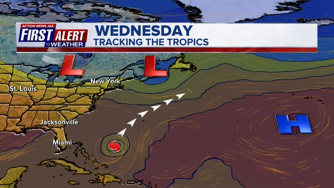
A more southern latitude tropical wave - ‘98-L’ that moved off of Africa last week is edging into the SE Caribbean with disorganized t’storm activity. This is a classic wave in that it formed from a complex of intense storms over Africa... encountered hostile conditions (shear & dry air) for days before finding more favorable conditions. Both the GFS & European global models have jumped on this wave now with potential development over the Caribbean by at least the weekend. The GFS is faster to develop the wave vs. the European but both models eventually show a hurricane if not over then near the Caribbean then over the Gulf of Mexico. The GFS is the farthest to the west before turning northward... The European is more east & earlier to turn north (interesting since the model keeps the disturbance more shallow/weaker for longer) & has trending that direction with each model run. Both are similar on timing with possible impacts for the Lower 48 of the U.S. late next week into the following weekend. There will be some interaction with the north coast of Colombia & Venezuela the next couple days which could limit overall organization but once the wave gains some latitude, it would appear most ingredients are in place for the development of a tropical cyclone over the Caribbean.
Hurricane hunter aircraft flew across the SE Caribbean & nearby areas Wed. evening & the weather data was ingested into the 00Z GFS model run. It’ll be interesting to see how this real-time data affects the output (forecast). I’m hoping real-time weather data is consistently inputted in the following days otherwise the model may have a tendency to jump around more than usual.
This disturbance will stay far to the south of recently hard hit Puerto Rico & Dominican Republic. The time table - *for right now* is Central/Eastern Caribbean through the weekend: near/south of Jamaica late in the weekend/early next week... the NW Caribbean/Southern Gulf by the middle of next week... into/over the Gulf of Mexico through late next week. Still very early on the path & strength of this *potential* storm. There will be changes, stay up to date!

Spaghetti plots for tropical wave ‘98-L’:


Tropical wave - ‘96-L’ was upgraded to tropical depression #7 Wed. morning then to tropical storm “Fiona” Wed. evening & to a hurricane Sun. morning with a Cat. 1 (85 mph winds) landfall Sunday afternoon about 3:20pm EDT along the southwest coast of Puerto Rico near Punta Tocon followed by another landfall (Cat. 1/90 mph winds) early Mon. at 3:30am EDT along the coast of the Dominican Republic near Boca de Yuma. The hurricane strengthened into a Cat. 2 late Mon. then to a ‘major’ hurricane early Tue. - the first major hurricane of the Atlantic season. The avg. date for such an occurrence is Sept. 1.
Fiona’s steering currents are pretty straight forward & locked in (hence, a narrow forecast cone). The strongest shear is now oriented north & east of the eye & Fiona will remain on the western edge of the westerly shear while maintaining strength over very warm ocean water with high humidity. There may be some eyewall replacement cycles causing fluctuations in intensity & structure, but all signs point to a powerful Cat. 3+ hurricane for much of the rest of this week. Of note - the center moving a little south of due west into the face of the shear - as was the case last Wed./Thu. & parts of Fri. - has led to eventually powerful hurricanes that had a similar trend. And indeed Fiona followed suit reaching Cat. 3 intensity Tue. & a Cat. 4 early Wed. A sharper turn to the north & northeast will take Fiona to near Bermuda by early Fri. then a turn back north, even a little NW over the N. Atlantic. Fiona will reach Jacksonville’s latitude - 700-900 miles to the east Thu. afternoon.
It’s possible that Fiona may try to become an annular hurricane (strong & steady state with essentially a singular band of intense convection wrapped around a usually rather wide eye) for a couple of days over the Western Atlantic.
FIONA SUMMARY/IMPACTS:
* Puerto Rico/U.S. Virgin Islands/nearby Caribbean islands: Improving weather & seas but river flooding will last longer with the typical lag between the end of the heaviest rain & the crest of major rivers.
* Most intense impacts for Hispaniola are easing, but there are still some bands of heavy t’storms due to a trailing trough of low pressure... Haiti escapes most of the wind & rain.
* Impacts to the Southeast Bahamas, especially the Turks & Caicos Islands - in the form of strong winds, heavy rain & rough seas/surf - continue to diminish. Most of the Central & NW Bahamas will get through Fiona unscathed.
* Impacts for Bermuda Thu. night/Fri. - wind/rain/rough seas/surf though the eye goes a little to the west & northwest of the island.
* Impacts for Nova Scotia & Newfoundland this weekend (becoming large/strong post-tropical ocean storm) - very heavy rain, strong winds, high seas, very rough surf.
* Increasing swells/seas/surf + dangerous rip currents for virtually all of the U.S. east coast through this week (but Fiona well offshore)
Forecast models remain in good agreement keeping Fiona well east of the U.S. mainland. The GFS remains a little faster & bit more east than the European model.
Tip of the hat to the GFS model for winning the model battle on Fiona.
The steering influences for Fiona are well developed in the form of an upper level trough moving to New England then the NW Atlantic while the Bermuda high is well to the east providing the distinct alleyway across the W. Atlantic for Fiona. The upper level trough then captures Fiona by this weekend bending the transitioning to a post-tropical low to the north & northwest late in the week/next weekend which has big implications for Nova Scotia & Newfoundland as the low will remain a powerful ocean storm even after losing tropical characteristics.


The alleyway for Fiona is well established as the Bermuda high shifts east & a series of upper level troughs move to the U.S. east coast & NW Atlantic:


Fiona is encountering higher shear again in the coming days, but the hurricane will likely be so well developed... moving more or less with the shear... over warm water with plenty of moisture that it’ll create its own favorable “island” to remain intense.


Hurricane hunter aircraft snapshot of the eye of Fiona early Tue.!:

Sunday:
#firstalertwx https://t.co/FdtG6zso0A
— Mike Buresh (@MikeFirstAlert) September 19, 2022
Elsewhere....
“Gaston” was upgraded Tue. & will stay over the Central & Northeast Atlantic while moving slowly northeast then bending sharply northwest early next week as it weakens. There are some indications on satellite imagery that Gaston might not be purely tropical, but - in any case - no impacts for the U.S.... rough seas/surf, some rain possibly for the Western Azores.

And there are a couple of active tropical waves over the Eastern Atlantic. There is the potential for some development with the lead wave slowly moving west or W/NW... followed by a wave near the African coast that’s should turn rather sharply northward soon. Neither wave is expected to be able to make it all the way across the Atlantic.


Water vapor loop shows plenty of mid & upper level moisture across a good part of the Atlantic Basin:


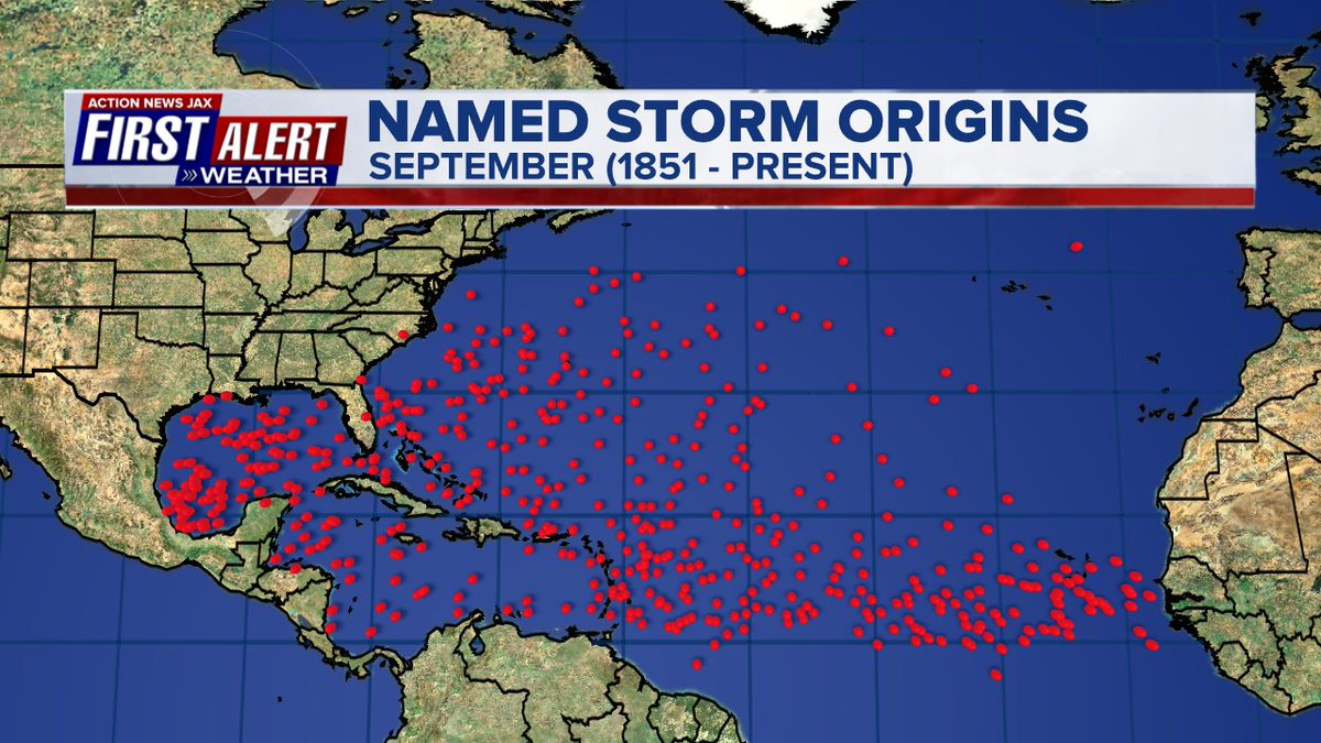
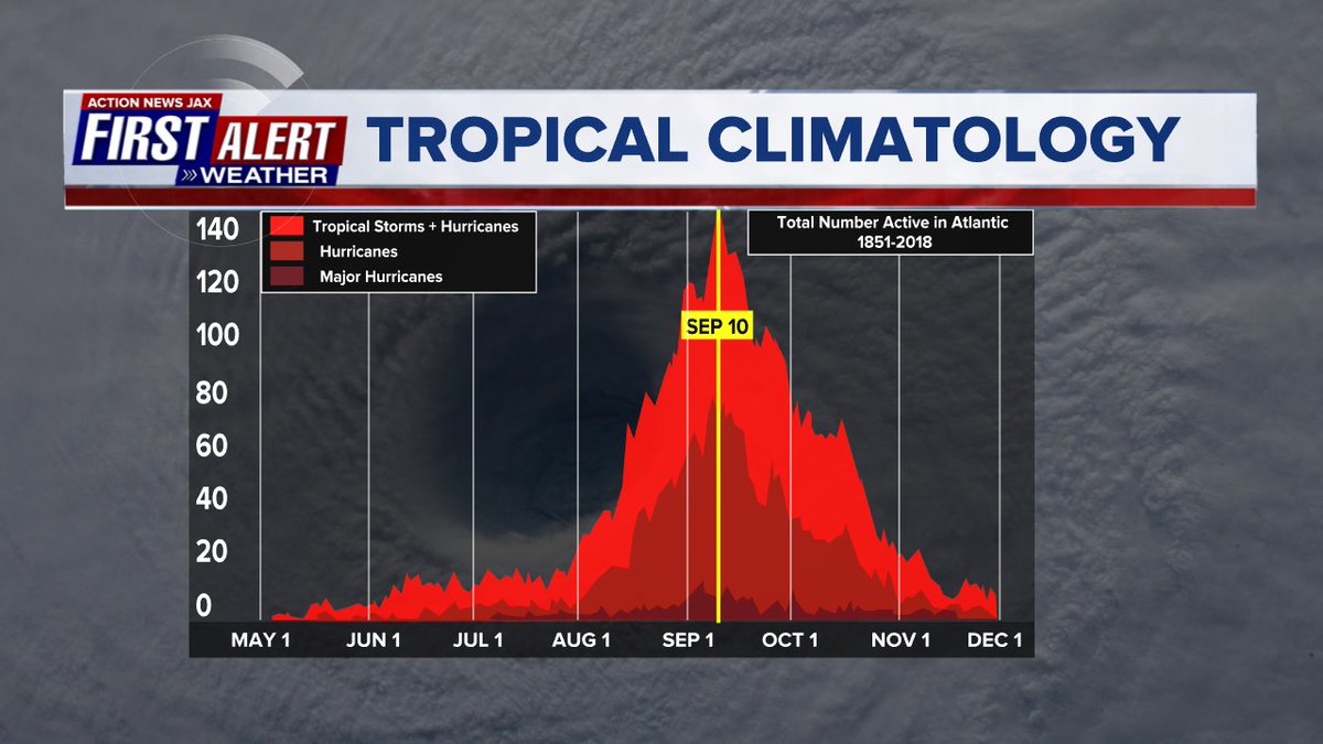
September origins:
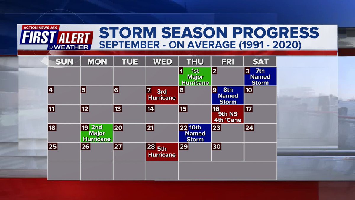
Averages below based on climatology for the Atlantic Basin through September. This season so far is well below avg.:
Wind shear:


Saharan dust spreads west each year from Africa by the prevailing winds (from east to west over the Atlantic). Dry air - yellow/orange/red/pink. Widespread dust is indicative of dry air that can impede the development of tropical cyclones. However, sometimes “wanna’ be” waves will just wait until they get to the other side of - or away from - the plume then try to develop if other conditions are favorable. In my personal opinion, way too much is made about the presence of Saharan dust & how it relates to tropical cyclones. In any case, we’ve had several large dust plumes spread west to the Caribbean & Gulf with the peak of Saharan dust typically in June & July.

2022 names..... “Hermine” is the next name on the Atlantic list (names are picked at random by the World Meteorological Organization... repeat every 6 years). Historic storms are retired [Florence & Michael in ’18... Dorian in ’19 & Laura, Eta & Iota in ‘20 & Ida in ‘21]). In fact, this year’s list of names is rather infamous with “Charley”, “Frances”, “Jeanne” & “Ivan” retired from the ‘04 list (all hit Fl.) & “Matthew” was retired in 2016. The WMO decided - beginning last year - that the Greek alphabet will be no longer used & instead there will be a supplemental list of names if the first list is exhausted (has only happened three times - 2005, 2020 & 2021). The naming of tropical cyclones began on a consistent basis in 1953. More on the history of naming tropical cyclones * here *.


East Atlantic:


Mid & upper level wind shear (enemy of tropical cyclones) analysis (CIMMS). The red lines indicate strong shear:

Water vapor imagery (dark blue indicates dry air):

Deep oceanic heat content over the Gulf, Caribbean & deep tropical Atlantic:

Sea surface temp. anomalies:


SE U.S. surface map:

Surface analysis centered on the tropical Atlantic:

Surface analysis of the Gulf:

Caribbean:

GFS wave forecast at 48 & 72 hours (2 & 3 days):


Atlantic Basin wave period forecast for 24, 48 & 72 hours respectively:


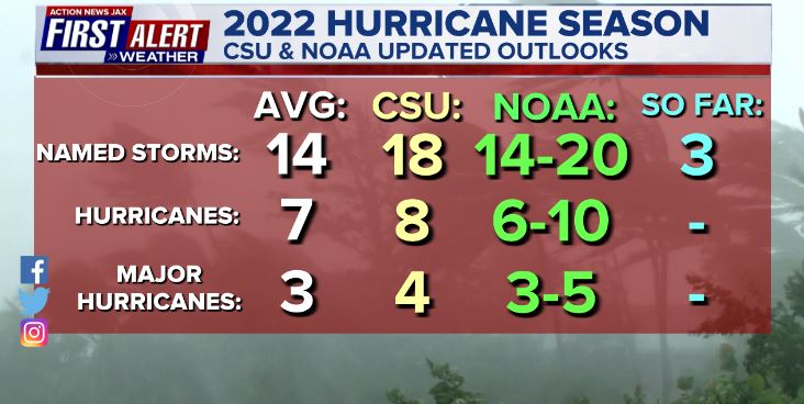
Updated Atlantic seasonal forecast from early Aug. - NOAA & CSU:
The East Pacific:
“Newton” has formed over the E. Atlantic & will move westward away from the Pacific coast of Mexico:


West Pacific:

Global tropical activity:


Cox Media Group
:quality(70)/cloudfront-us-east-1.images.arcpublishing.com/cmg/HJ3L3HBBJBH6PB5ZFB3SVGFXSU.png)
:quality(70)/cloudfront-us-east-1.images.arcpublishing.com/cmg/4TQDXERT5VGORNZ4NQWXNO5H64.png)
:quality(70)/cloudfront-us-east-1.images.arcpublishing.com/cmg/SKX4RKW645ERTATCLA4V2FVRKQ.png)
:quality(70)/cloudfront-us-east-1.images.arcpublishing.com/cmg/TYVIYUNT7BBHDLGYYWGCJB424E.png)
:quality(70)/cloudfront-us-east-1.images.arcpublishing.com/cmg/WYUHBF3SFRC7HITANNA24VG6DI.jpg)
:quality(70)/cloudfront-us-east-1.images.arcpublishing.com/cmg/V7JDMMD6JJEEHIL6C7OSLV3ABU.png)
:quality(70)/cloudfront-us-east-1.images.arcpublishing.com/cmg/QMKROHYW2EYLHCMGRD4HWX6TMI.jpg)
:quality(70)/cloudfront-us-east-1.images.arcpublishing.com/cmg/S2C6YCA5MCM32TIEGFMN5WLVVM.jpg)
:quality(70)/cloudfront-us-east-1.images.arcpublishing.com/cmg/6K5FP45U3QY5IH7CO44G6Q64ZE.jpg)
 Sign Up

