:quality(70)/cloudfront-us-east-1.images.arcpublishing.com/cmg/WW5AJL3ARQUGDQMAQUNSFX4CLE.jpg)
Jacksonville, Fl. — The “Buresh Bottom Line”: Always be prepared!.....First Alert Hurricane Survival Guide... City of Jacksonville Preparedness Guide... Georgia Hurricane Guide.
STAY INFORMED: Get the * FREE * First Alert Weather app
FREE NEWS UPDATES, ALERTS: Action News Jax app for Apple | For Android
WATCH “Talking & Tracking the Tropics: The Science Behind the Season”
WATCH “Preparing for the Storm”
READ the First Alert Hurricane Center “Survival Guide”
***** ALWAYS CHECK & RE-CHECK THE LATEST FORECAST & UPDATES! *****
*** Low pressure/tropical wave ’92-L’/‘Potential Cyclone Nine’ was upgraded to tropical storm Isaias Wed. evening while over the Eastern Caribbean.... moved over Eastern Dominican Republic Thu. afternoon then offshore & quickly reorganized becoming the 2nd hurricane of the Atlantic season a little before midnight. Isaias quite literally fell apart Sat. afternoon while crossing Andros Island of the Bahamas & the mid & low level centers have pretty much been disjointed ever since. Isaias is the 5th July named storm over the Atlantic which ties the record for the month set in 2005. It marks the fastest to ‘I’ beating the previous record set by “Irene” in - when else - 2005.
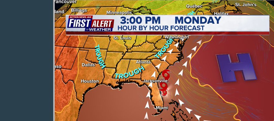
LOCAL JACKSONVILLE/NE Fl./SE Ga.:
Isaias moved northward well east of the Fl. coast Sun. night through Mon. morning with virtually all the “weather” - strongest winds & heaviest rain - north & east of the center. The track of the center was ~75-100+ miles east of NE Fl./SE Ga. & Jacksonville. There is a window of opportunity for Isaias to intensify up to landfall but well northeast of Jacksonville but will be a relatively moot point for our sensible weather on the west (kinder, gentler) side.
On this track, impacts locally - *have not* been severe - for Jax/NE Fl./SE Ga:
* scattered showers / rain bands end as drier air flows across the area. Amounts have been mostly less than an inch. In fact, afternoon storms will drop more rain than Isaias did.
* a dangerous rip current risk at area beaches through Mon. night with rough seas & surf. The best advice is to stay out of the ocean through Monday... conditions will improve Tue. but beware of scouring in the sand at the beaches from the recent heavy wave action.
* water levels will recede but ocean water will take a while to completely escape so tides will still be a little above avg. through at least Tue. There will also be some astronomical boost with the full moon Monday/Tue. Forecast tides * here *.
* Winds will quickly diminish while becoming offshore (out of the west).
FORECAST DISCUSSION & REASONING:
Isaias remained reasonably well organized after traversing the rugged terrain of the Dominican Republic Thu. missing some of the highest mountainous peaks. Moving at more than 20 mph, Isaias did not stay over land for much more than 8-10 hours. However, Isaias struggled mightily Sat. afternoon while passing over the N. Andros Island of the Bahamas. At one point, the center was completed exposed & mostly void of convection. But then there was a big burst of t’storms near & north of the center Sat. evening which then gave way to the ongoing west/southwest shear followed by another burst Sunday morning that likewise eventually did succumb to the shear. Vigorous t’storm activity has become persistent since Sunday afternoon but with two centers on radar imagery - a low level circulation closer to the coast & a midlevel circulation to the northeast. There have been hints of an attempt at a developing eye on radar imagery. There is very warm ocean water ahead (Gulf Stream).
Forecast models have generally converged on a solution that takes Isaias into the Carolina’s by early Mon. night... across Chesapeake Bay to near New York City Tue. then to Western New England Tue. night/early Wed. as the storm accelerates northeast while coming under the influence of an upper level trough approaching from the west.
There continues to be an alleyway near the U.S. east coast/far W. Atlantic. The approaching upper level trough moving into the Eastern U.S. will help eventually steer Isaias more north/northeast then northeast up the eastern seaboard.

Radar imagery below with forecast track of Isaias courtesy S. Fl. Water Management District:


Spaghetti plots:


Water vapor imagery shows the continental dry air rushing east underneath/south of Isaias:


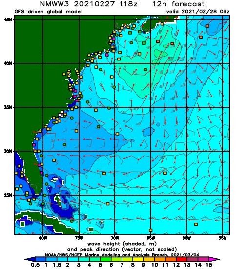
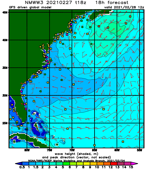
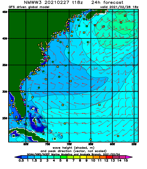
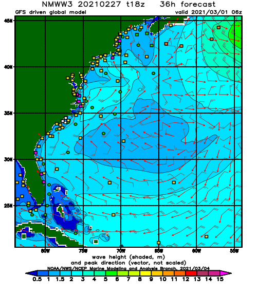
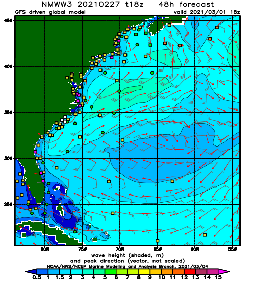
NOAA WaveWatch III “Significant Wave Height” forecast:
Current shear:

Rainfall forecast:


Projected path of Isaias in red vs. Floyd, 1999/Matthew, 2016/Dorian, 2019. It should be noted that Floyd, Matthew & Dorian were considerably stronger & larger tropical cyclones....
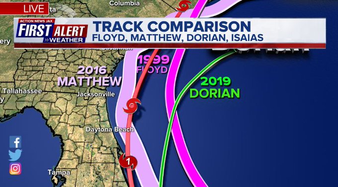
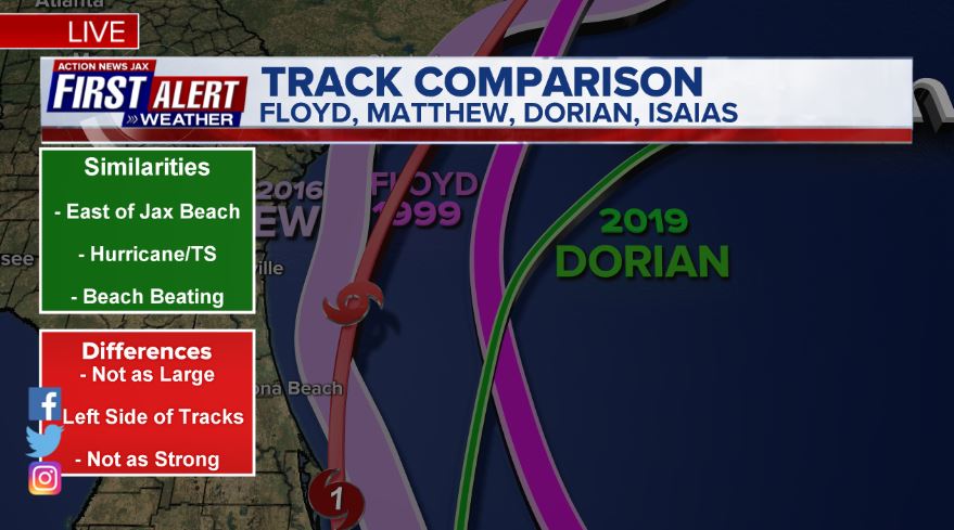
So is there is precedence for a Fl. east coast “hugger” though such a track is not real common. Hurricane David comes to mind in 1979, late August. David was much larger & stronger & even a little west of Isaias. Note the “hole” in the heaviest rain right over Jacksonville/NE Fl. Pretty likely we’ll see a similar scenario with Isaias.


Meanwhile... a tropical wave has some potential to develop some over the Central Atlantic while moving northwest. Early indications are that this will turn more north with time staying east of the U.S. & north of the Caribbean & Greater & Lesser Antilles.

And t.d. #10 formed just off the coast of Africa Fri. over the far E. Atlantic but has dissipated.


:quality(70)/cloudfront-us-east-1.images.arcpublishing.com/cmg/HJ3L3HBBJBH6PB5ZFB3SVGFXSU.png)
:quality(70)/cloudfront-us-east-1.images.arcpublishing.com/cmg/4TQDXERT5VGORNZ4NQWXNO5H64.png)
:quality(70)/cloudfront-us-east-1.images.arcpublishing.com/cmg/SKX4RKW645ERTATCLA4V2FVRKQ.png)
:quality(70)/cloudfront-us-east-1.images.arcpublishing.com/cmg/5PIZRG7NYBAHDDABTG5BNVGO6Y.jpg)
:quality(70)/cloudfront-us-east-1.images.arcpublishing.com/cmg/V7JDMMD6JJEEHIL6C7OSLV3ABU.png)
:quality(70)/cloudfront-us-east-1.images.arcpublishing.com/cmg/33B73OT6W3Z77XMU2GXVQQZ6GE.jpg)
:quality(70)/cloudfront-us-east-1.images.arcpublishing.com/cmg/VH7BQKFH72ZQ7FAA6EUDFVJNAA.jpg)
:quality(70)/cloudfront-us-east-1.images.arcpublishing.com/cmg/LYXELYCV5G7WBT7663ANY5MQFQ.jpg)
 Sign Up

