:quality(70)/cloudfront-us-east-1.images.arcpublishing.com/cmg/WW5AJL3ARQUGDQMAQUNSFX4CLE.jpg)
Jacksonville, Fl. — The “Buresh Bottom Line”: Always be prepared!.....First Alert Hurricane Survival Guide... City of Jacksonville Preparedness Guide... Georgia Hurricane Guide.
STAY INFORMED: Get the * FREE * First Alert Weather app
FREE NEWS UPDATES, ALERTS: Action News Jax app for Apple | For Android
WATCH “The Ins & Outs of Hurricane Season”
WATCH “Preparing for the Storm”
READ the First Alert Hurricane Center “Survival Guide”
***** ALWAYS CHECK & RE-CHECK THE LATEST FORECAST & UPDATES! *****
Weak low pressure has formed north of the Bahamas & east of NE Florida. Though a bit better organized, the sytsem is expected to stay weak through the weekend though a tropical depression is not out of the question. Forecast models have come into better agreement now on a more westward movement possibly crossing Florida Sunday/Sunday night while weakening. For Jacksonville/NE Fl./SE Ga.:
* breezy northeast winds creating potentially dangerous rip currents at area beaches
* in combination with a full moon, higher than avg. tides causing minor, localized flooding at some parts of the coast & along the St. Johns River & its tributaries
* a few showers Sunday/Sunday night
A pesky old frontal boundary remains stretched out/stalled across the W. Atlantic to S. Carolina & Georgia & is being reinforced somewhat by a weak piece of an upper level trough that will evolve over the Southeast/Eastern U.S./SW Atlantic through the weekend. While conditions (shear especially) are not particularly favorable for much development, close proximity to the Gulf Stream is a bit disconcerting. As an upper level ridge builds to the north as an upper level trough moves over the N. Atlantic (the Euro had this trough picking up this low the past few days), the low will drift west through the weekend & is likely to weaken into a trough of low pressure by Monday or so while moving over the Gulf of Mexico. Again - this is not likely to be a strong system but rainfall will increase across especially Central & South Fl.


South Fl. Water Management District:


Saharan dust. Dry air - yellow/orange/red/pink - is extensive over the Caribbean & Central & Eastern Atlantic. Such widespread dust is common early in the hurricane season - through July - & is indicative of dry air that can impede the development of tropical cyclones. However, sometimes “wanna’ be” waves will just wait until they get to the other side of the plume then try to develop if everything else happens to be favorable.

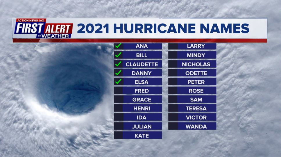
2021 names..... “Fred” is the next name on the Atlantic list (names are picked at random by the World Meteorological Organization... repeat every 6 years... historic storms are retired (Florence & Michael in ’18... Dorian in ’19 & Laura, Eta & Iota in ‘20). Last year - 2020 - had a record 30 named storms. The WMO decided beginning in 2021 that the Greek alphabet will be no longer used & instead there will be a supplemental list of names if the first list is exhausted (has only happened twice - 2005 & 2020). More on the history of naming tropical cyclones * here *.


East Atlantic:


Mid & upper level wind shear (enemy of tropical cyclones) analysis (CIMMS). The red lines indicate strong shear which is widespread from the Gulf of Mexico & Caribbean eastward across much of the Atlantic:

Water vapor imagery (dark blue indicates dry air):

Deep oceanic heat content is slowly increasing across the SE Gulf, Caribbean & deep tropical Atlantic:

Sea surface temp. anomalies:


SE U.S. surface map:

Surface analysis centered on the tropical Atlantic:

Surface analysis of the Gulf:

Caribbean:

Atlantic Basin wave forecast for 24, 48 & 72 hours respectively:


The E. Pacific has gone quiet now....

In the W. Pacific.... broad-eyed typhoon “In-Fa” is forecast to turn more northwest staying well northeast of Taiwan (but with fringe effects for Northern Taiwan) through the weekend & well south & west of Japan.
A second system - “Nepartak” - is developing over the W. Pacific & could impact Japan - including Tokyo - by the middle of next week but is not expected to be a strong storm. Nonetheless, some heavy rain may affect the Olympic games next week depending on the location & intensity of Nepartak.


Global tropical activity:


Cox Media Group
:quality(70)/cloudfront-us-east-1.images.arcpublishing.com/cmg/HJ3L3HBBJBH6PB5ZFB3SVGFXSU.png)
:quality(70)/cloudfront-us-east-1.images.arcpublishing.com/cmg/4TQDXERT5VGORNZ4NQWXNO5H64.png)
:quality(70)/cloudfront-us-east-1.images.arcpublishing.com/cmg/SKX4RKW645ERTATCLA4V2FVRKQ.png)
:quality(70)/cloudfront-us-east-1.images.arcpublishing.com/cmg/5PIZRG7NYBAHDDABTG5BNVGO6Y.jpg)
:quality(70)/cloudfront-us-east-1.images.arcpublishing.com/cmg/V7JDMMD6JJEEHIL6C7OSLV3ABU.png)
:quality(70)/cloudfront-us-east-1.images.arcpublishing.com/cmg/WA5FNXO2RGWUZ6ETRASHYWTFTU.jpg)
:quality(70)/cloudfront-us-east-1.images.arcpublishing.com/cmg/NNKCBGCDIZSDZMFAOUGJRLR7F4.jpg)
:quality(70)/cloudfront-us-east-1.images.arcpublishing.com/cmg/5ISYLSEPED2JGPMBZS2NJYGEQ4.jpg)
 Sign Up

