:quality(70)/cloudfront-us-east-1.images.arcpublishing.com/cmg/WW5AJL3ARQUGDQMAQUNSFX4CLE.jpg)
Jacksonville, Fl. — The “Buresh Bottom Line”: Always be prepared!.....First Alert Hurricane Survival Guide... City of Jacksonville Preparedness Guide... Georgia Hurricane Guide.
STAY INFORMED: Get the * FREE * First Alert Weather app
FREE NEWS UPDATES, ALERTS: Action News Jax app for Apple | For Android
WATCH “Talking & Tracking the Tropics: The Science Behind the Season”
WATCH “Preparing for the Storm”
READ the First Alert Hurricane Center “Survival Guide”
***** ALWAYS CHECK & RE-CHECK THE LATEST FORECAST & UPDATES! *****
The Caribbean/Gulf of Mexico & SW Atlantic will remain the areas to keep an eye on over the next couple of weeks (climatologically favored too).
*** Everyone along the Gulf Coast between Texas & Florida should stay up to date on the latest forecasts as a tropical system moves into the Gulf of Mexico during the upcoming week.....
Monitoring:
(1) low pressure over the Central Atlantic evolved from an upper low, became t.d. #27 Mon. morning & then to tropical storm Epsilon within a few hours - the fastest to the 27th storm breaking the record set in - of course - 2005.... & became a hurricane Tue. strengthening into a Cat. 3 Wed. before leveling off again as a Cat. 2 & then steady state as a Cat. 1. While the core of the hurricane missed Bermuda to the east Thu., strong winds & rough seas/surf will be slow to recede over the weekend. Easterly swells will enhance rough surf & the rip current risk for the Bahamas, Florida & much of the U.S. east coast through Sunday.
(2) An inverted surface trough (“band” of lower pressures creating convergence) continues near & just east of Fl. through the weekend which can sometimes lead to low pressure then tropical development, especially late in the season. Weak low pressure may eventually evolve over the Bahamas or between the Bahamas & Florida. No significant development is expected as any low that might develop moves northeast over the Atlantic.
Of much greater concern....T’storm activity has increased near/south of Cuba near the Cayman Islands with low pressure now evident at the surface. The disturbance should drift to the northwest before turning north then northeast. Forecast models seem to be finally(!) catching on to this development. The European is the farthest west & slowest (true all season) - west of New Orleans Friday.... the GFS model is later Thu. near New Orleans... the UKMET is again the go-between bringing the system ashore Thu. night/early Fri. very near New Orleans - closer in location to the GFS but a little west.... & east of the Euro.


Caribbean disturbance:


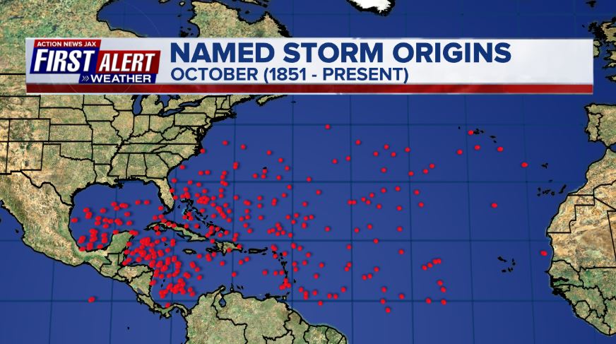
October tropical cyclone origin points are clustered over the Caribbean, Gulf of Mexico & SW Atlantic:
Atlantic Basin wave forecast for 24, 48 & 72 hours respectively:


:quality(70)/cloudfront-us-east-1.images.arcpublishing.com/cmg/HJ3L3HBBJBH6PB5ZFB3SVGFXSU.png)
:quality(70)/cloudfront-us-east-1.images.arcpublishing.com/cmg/4TQDXERT5VGORNZ4NQWXNO5H64.png)
:quality(70)/cloudfront-us-east-1.images.arcpublishing.com/cmg/SKX4RKW645ERTATCLA4V2FVRKQ.png)
:quality(70)/cloudfront-us-east-1.images.arcpublishing.com/cmg/TYVIYUNT7BBHDLGYYWGCJB424E.png)
:quality(70)/cloudfront-us-east-1.images.arcpublishing.com/cmg/WYUHBF3SFRC7HITANNA24VG6DI.jpg)
:quality(70)/cloudfront-us-east-1.images.arcpublishing.com/cmg/V7JDMMD6JJEEHIL6C7OSLV3ABU.png)
:quality(70)/cloudfront-us-east-1.images.arcpublishing.com/cmg/XSVSI2SWXFKG3TJZJLCQK7ZJAQ.jpg)
:quality(70)/cloudfront-us-east-1.images.arcpublishing.com/cmg/K4CTEOFC76WOQ5N7QBIAJXNXLI.jpg)
:quality(70)/cloudfront-us-east-1.images.arcpublishing.com/cmg/XOHUJUTJPZQMZKDO7KGNFOXYI4.jpg)
 Sign Up

