:quality(70)/cloudfront-us-east-1.images.arcpublishing.com/cmg/WW5AJL3ARQUGDQMAQUNSFX4CLE.jpg)
Jacksonville, Fl. — The “Buresh Bottom Line”: Always be prepared!.....First Alert Hurricane Survival Guide... City of Jacksonville Preparedness Guide... Georgia Hurricane Guide.
STAY INFORMED: Get the * FREE * First Alert Weather app
FREE NEWS UPDATES, ALERTS: Action News Jax app for Apple | For Android
WATCH “Talking & Tracking the Tropics: The Science Behind the Season”
WATCH “Preparing for the Storm”
READ the First Alert Hurricane Center “Survival Guide”
***** ALWAYS CHECK & RE-CHECK THE LATEST FORECAST & UPDATES! *****
Tropical waves continue to roll west off the coast of Africa. It’s just a matter of time before one of these waves “takes off” but atmospheric conditions - right now - are not particularly conducive for development.
One wave in particular is strong & shows signs of organization just off the African coast. This wave could become a tropical storm within the next few days. The environment appears marginal which could keep the wave “in check”.
We also need to monitor the Western Caribbean &/or Gulf of Mexico for possible development over the next week or two as waves get farther west into a more favorable area for development.
Overall conditions over the Atlantic Basin appear “ready to go” as we head into mid to late Aug. - particularly the 20th-31st then on into Sept.

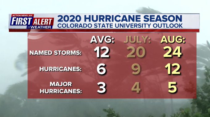
Wed., 08/05 it was Dr. Klotzbach at CSU... Thu., 08/06 it was NOAA with their hurricane season updated forecasts. Both are predicting a potentially historic last half of the hurricane season. Bottom line: always be prepared & stay calm. First Alert Hurricane Center * here *.


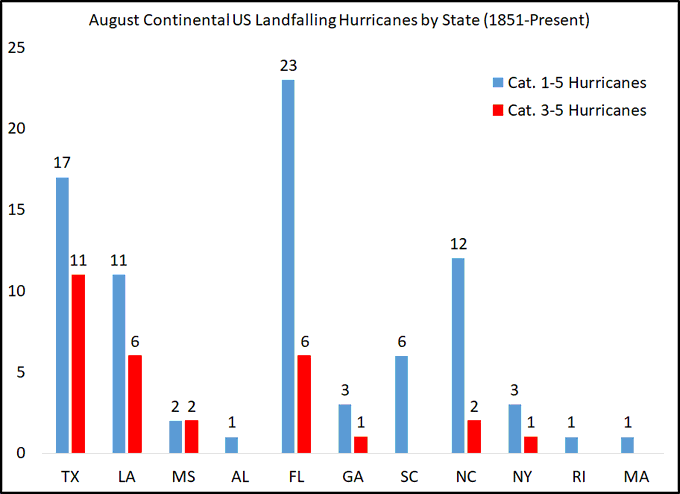
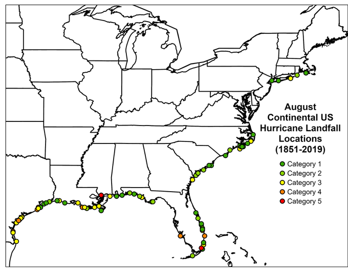
The graph & map below - the next 2 images - courtesy Dr. Phil Klotzbach showing Aug. landfalling hurricanes:


:quality(70)/cloudfront-us-east-1.images.arcpublishing.com/cmg/HJ3L3HBBJBH6PB5ZFB3SVGFXSU.png)
:quality(70)/cloudfront-us-east-1.images.arcpublishing.com/cmg/4TQDXERT5VGORNZ4NQWXNO5H64.png)
:quality(70)/cloudfront-us-east-1.images.arcpublishing.com/cmg/SKX4RKW645ERTATCLA4V2FVRKQ.png)
:quality(70)/cloudfront-us-east-1.images.arcpublishing.com/cmg/TYVIYUNT7BBHDLGYYWGCJB424E.png)
:quality(70)/cloudfront-us-east-1.images.arcpublishing.com/cmg/WYUHBF3SFRC7HITANNA24VG6DI.jpg)
:quality(70)/cloudfront-us-east-1.images.arcpublishing.com/cmg/V7JDMMD6JJEEHIL6C7OSLV3ABU.png)
:quality(70)/cloudfront-us-east-1.images.arcpublishing.com/cmg/EGP56GZAVYUTQNWNT47DAQJDGI.jpg)
:quality(70)/cloudfront-us-east-1.images.arcpublishing.com/cmg/SX2N4TYKQIC36CAXHOGPUSPTHM.jpg)
:quality(70)/cloudfront-us-east-1.images.arcpublishing.com/cmg/YHX4KCCANPJTZMX3SHEKE2UJ3A.jpg)
 Sign Up

