JACKSONVILLE, Fla. — To become a part of the First Alert Neighborhood weather station network powered by Tempest - scan below &/or click * here *:

We - Jacksonville/NE Florida/SE Georgia - are dry! Since the last month of the “wet season”, rainfall is nearly a foot below average at JIA including an entire month - Nov. - with no rain at all. Only the second month on record in Jacksonville - since 1871 - with zero rainfall.

U.S. drought monitor map for the Southeast U.S.:

So the wildfire threat is serious across the local area. Several wildfires have recently ignited but - so far - the fires have generally been brought under control relatively quickly. The pic below is from the JFRD & a 3 acre brushfire on the west edge of the UNF campus.

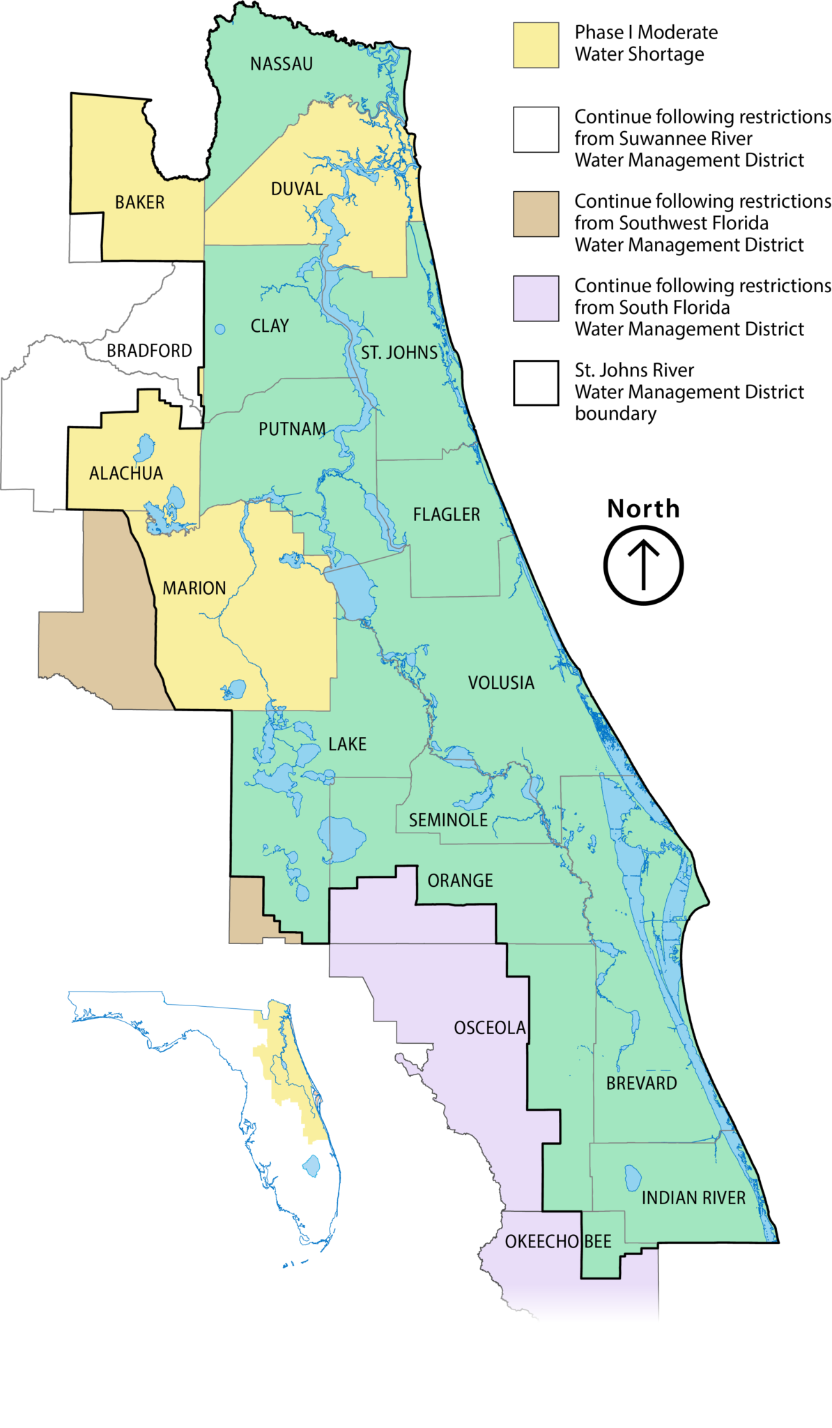
Water Shortage: The St. Johns River Water Management District (District) Governing Board voted to declare a Phase I Moderate Water Shortage for Duval County and portions of Alachua, Baker, Bradford and Marion counties.
District staff evaluated rainfall totals, groundwater levels, river flows and current drought conditions prior to recommending the declaration. Countywide rainfall totals for Alachua, Baker, Bradford, Duval and Marion counties were at or below 40 inches for the past year, and some groundwater monitoring locations in Marion and Duval counties were at or below the 15th percentile. According to the U.S. Drought Monitor, portions of the region are classified as being in severe or extreme drought.
Under a Phase I Water Shortage, all water users are encouraged to voluntarily reduce water use and conserve water to the maximum extent possible. Wasteful and unnecessary water use is prohibited. Water users are also encouraged to proactively plan for extended dry conditions and the potential for additional mandatory restrictions should the water shortage advance to a more severe phase.
The order encourages voluntary reductions across all water use sectors, including public supply, commercial, industrial, institutional, agricultural, landscape, recreation and aesthetic uses. Property owners and managers are encouraged to prepare for possible worsening conditions.
Public water utilities are asked to review and fully implement existing water conservation plans, evaluate additional demand management measures and enhance customer messaging to help reduce water use during the shortage.
The declaration applies to:
- Portions of Baker, Bradford and Duval counties within the District
- Portions of Alachua County within the District, excluding unincorporated areas overseen by the Suwannee River Water Management District
- Portions of Marion County within the District, the City of Ocala and unincorporated areas of Marion County, excluding areas overseen by the Southwest Florida Water Management District
The District’s Water Shortage Plan allows for additional restrictions if conditions continue to deteriorate. The declaration also delegates authority to the executive director to expand water shortage declarations if needed.
Jacksonville is coming off about a 2-week period of very cold temps. that include two record lows. It was only a few weeks before - in mid January - that we had a quick shot of record high temps. So we’ve endured a lot of bouncing around which is not uncommon during the winter but La Nina (cooler than avg. water near the equatorial Pacific) winters have a tendency to be locally more extreme (big temp. fluctuations). Below are the record lows & highs for JIA (official Jacksonville temp.) since 2004 - 85 record lows & 199 record highs over 22 years & 2 months:


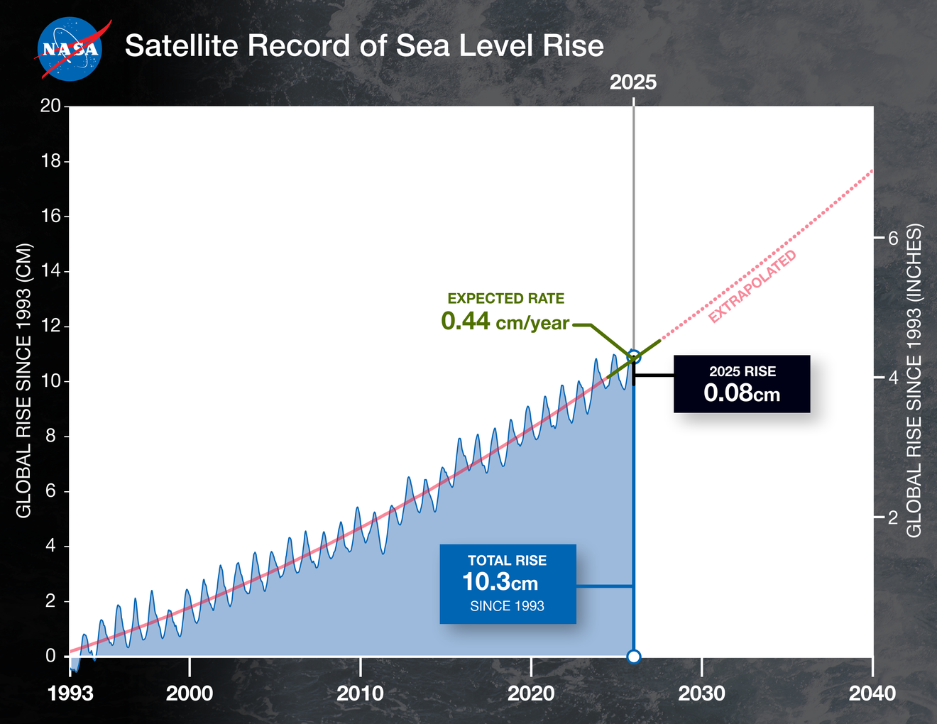
NASA has released a story that shows La Nina may have slowed (or “limited”) sea level rise during the past year.
The rise in the global mean sea level slowed in 2025 relative to the year before, an effect largely due to the La Niña conditions that persisted over most of the year. According to a NASA analysis, the average height of the ocean increased last year by 0.03 inches (0.08 centimeters), down from 0.23 inches (0.59 centimeters) in 2024.
The 2025 figure also fell below the long-term expected rate of 0.17 inches (0.44 centimeters) per year based on the rate of rise since the early 1990s. Though sea levels have increasingly trended upward in that period, years during which the rise in the average height was less usually have occurred during La Niñas — the part of the El Niño-Southern Oscillation cycle that cools the eastern Pacific Ocean, often leading to heavy rainfall over the equatorial portions of South America.