
Jacksonville, Fl. — The “Buresh Bottom Line”: Always be prepared!.....First Alert Hurricane Survival Guide... City of Jacksonville Preparedness Guide... Georgia Hurricane Guide.
STAY INFORMED: Get the * FREE * First Alert Weather app
FREE NEWS UPDATES, ALERTS: Action News Jax app for Apple | For Android
WATCH “The Ins & Outs of Hurricane Season”
WATCH “Preparing for the Storm”
READ the First Alert Hurricane Center “Survival Guide”
***** ALWAYS CHECK & RE-CHECK THE LATEST FORECAST & UPDATES! *****
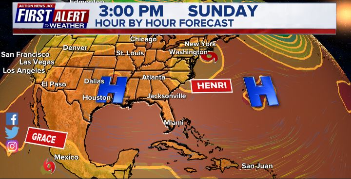
Forecast local - Jax/NE Fl./SE Ga. impacts from “Grace” & “Henri”: None (except for a “bump” in the surf from distant Henri at area beaches through Sat. resulting in a heightened rip current risk)
REMEMBER!: Taping windows is *NOT* helpful & will not keep glass from breaking... & realize the cone is the average forecast error over a given time - out to 5 days - & *does not* indicate the width of the storm &/or damage.

HENRI:
A disturbance over the Western Atlantic became tropical depression #8 Sun. night then upgraded to tropical storm “Henri” Mon. afternoon. Only two other infamous hurricane seasons have made it to ‘H’ by Aug. 16th - 2020 & 2005. Henri became a hurricane 6 days later - Sat. morning while turning northward over the Gulf Stream well to the east of the Carolina’s then back to a tropical storm Sunday morning upon approach to the Northeast U.S.
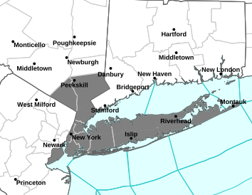
The area from New York City & Long Island through most of New England are going to experience a strong tropical storm through Sunday night then a slow moving rain storm for New England Monday. A rather classic - & about 2-3 times in a lifetime event - is unfolding for the NE U.S. An approaching upper level trough moving into the Great Lakes & Northeast U.S. is capturing Henri turning the storm to the north/northwest bringing the tropical cyclone ashore midday Sunday. The European has now caught on (had taken the storm out to sea) & all the models show reasonably similar timing & location with a landfall near the eastern edge of Long Island to near New London & southwest of Providence, Rhode Island followed by a turn northwest inland. The UKMET & European still have a sharper turn to the northwest while moving inland. The GFS is a little more east with less of a turn to the northwest. There’s no good reason to bet against the GFS model since it’s been better on Henri so far & was the first of the global models to trend west during the past week. Now north of the Gulf Stream, sea surface temps. are much cooler [above avg. but still below 80 degrees F]. However, the combination of Henri’s fast movement & added ventilation (upper level diffluence) from the approaching trough will likely allow for the storm to remain a strong tropical storm right up to landfall. The area is coming off of a very wet July so widespread flash flooding will be a concern in addition to the strong winds & isolated tornadoes. Widespread power outages & road closures seem quite plausible. Storm surge up to 5 feet will occur along some parts of Long Island, Cape Cod, Nantucket, Buzzards Bay.
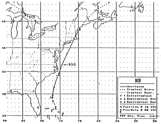
It looks like it will remain 30 years - Aug. 19th, 1991 - since the last hurricane - “Bob” - made landfall on the Southern New England coast, but Henri will still be a very impactful storm.
Anyone living in - or traveling to - the Northeast through early next week needs to stay up to date on the latest forecasts!


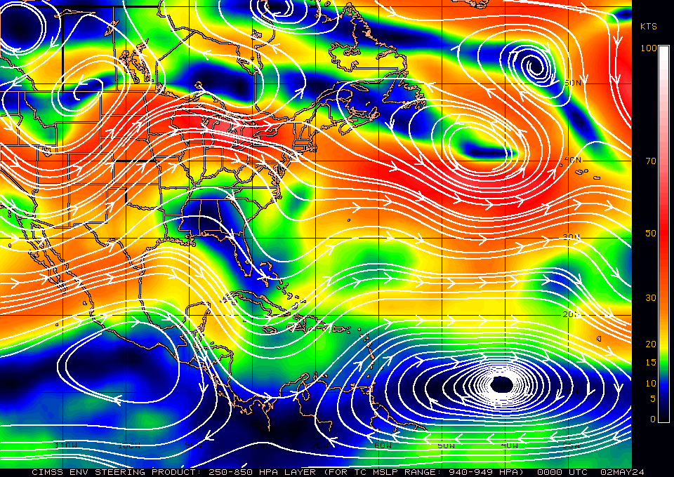
The 500 mb (about 30,000 feet) forecast for Sunday afternoon shows the split Bermuda high allowing an alley of least resistance for Henri to funnel through:

The last hurricane to make a direct landfall on New England - “Bob” - came from the southwest while arching northeast missing Long Island to the east. Cat. 2 “Gloria” made landfall on Long Island on Sept. 27, 1985. Ironically... the remnants of “Henri” brought some rain to Long Island two days earlier in the same year.
GRACE:
Tropical wave ‘95-L’ became tropical depression #7 Fri. afternoon & was upgraded to tropical storm “Grace” while steadily & quickly moving west/northwest. The five earliest named 7th storms of the season (Klotzbach): 2020 (7/22) 2005 (7/24) 1995 (8/10) 2017 (8/13) 2011 (8/14). Grace weakened back to a depression Sunday before returning to tropical storm status early Tue. then becoming a hurricane Wed. morning. A Cat. 1 landfall with winds estimated near 80 mph occurred on the Yucatan Peninsula about 5:45am EDT Thu. near Tulum, Mexico. Wind gusts near hurricane strength were measured at the Cancun Int’l. airport. Grace weakened to a tropical storm while traversing the Peninsula but regained hurricane status rather quickly early Friday making a second landfall early Sat. near 2am EDT near Tecolutla, Mexico as a Cat. 3 - the first “major” (Cat. 3, 4 or 5) of the Atlantic season. The last NHC advisory was issued late Sat. as Grace became a remnant low well inland over Mexico, but the remnants will re-emerge over the East Pacific potentially forming another storm that looks to track a little south of the Baja of California.
Elsewhere... a series of tropical waves continues to move west off the coast of Africa with multiple “threats” over the next few weeks. A wave now over the Eastern Atlantic has potential to develop but early indications are that this one stays well east over the Central Atlantic in the long run.
Long range forecast models do point to a tropical wave east of Fl. & near the Bahamas by late in the upcoming week, so let’s keep an eye on that one though the forecast models maintain an open wave with little or no surface development.
And there are long term “suggestions” of more tropical development in or near the Caribbean &/or Gulf of Mexico toward the end of the month/early Sept.
The peak of the Atlantic hurricane season is Sept. 10th.

We’re now under 3 weeks from the peak of the hurricane season (Sept. 10), so just from a climatological point, we should see an uptick in Atlantic activity. But there are also other indications of a more active period or “burst” with the MJO, seasonally warm sea surface temps. & rather impressive deep oceanic heat content.
Sea surface temps. across the Atlantic are now near to above avg. across much of the basin (2nd image below) & - even more importantly - deep oceanic heat content is becoming impressive & the “equivalent oceanic heat content” - namely depth averaged temperature in the upper 300 m (~984 feet) - is even more impressive all the way from Africa to the Gulf of Mexico. Such an ocean water temp. pattern is conducive to long track deep tropical Atlantic tropical cyclones & can lead to a more favored regime for rapid intensification cycles. From an AMS research paper in ‘08 Mainelli, DeMaria, Shay, Goni: “Results show that for a large sample of Atlantic storms, the OHC variations have a small but positive impact on the intensity forecasts. However, for intense storms, the effect of the OHC is much more significant, suggestive of its importance on rapid intensification. The OHC input improved the average intensity errors of the SHIPS forecasts by up to 5% for all cases from the category 5 storms, and up to 20% for individual storms, with the maximum improvement for the 72–96-h forecasts. The statistical results obtained indicate that the OHC only becomes important when it has values much larger than that required to support a tropical cyclone.” More recent research continues to indicate similar correlations.


Saharan dust. Dry air - yellow/orange/red/pink. Widespread dust is most common earlier in the hurricane season & is indicative of dry air that can impede the development of tropical cyclones. However, sometimes “wanna’ be” waves will just wait until they get to the other side of the plume then try to develop if everything else happens to be favorable.

2021 names..... “Ida” is the next name on the Atlantic list (names are picked at random by the World Meteorological Organization... repeat every 6 years... historic storms are retired (Florence & Michael in ’18... Dorian in ’19 & Laura, Eta & Iota in ‘20). Last year - 2020 - had a record 30 named storms. The WMO decided beginning in 2021 that the Greek alphabet will be no longer used & instead there will be a supplemental list of names if the first list is exhausted (has only happened twice - 2005 & 2020). More on the history of naming tropical cyclones * here *.


East Atlantic:


Mid & upper level wind shear (enemy of tropical cyclones) analysis (CIMMS). The red lines indicate strong shear:

Water vapor imagery (dark blue indicates dry air):

Deep oceanic heat content continues to increase across the Gulf, Caribbean & deep tropical Atlantic & has become pretty impressive from the Central/NW Caribbean into the Gulf of Mexico:

Sea surface temp. anomalies:

SE U.S. surface map:

Surface analysis centered on the tropical Atlantic:

Surface analysis of the Gulf:

Caribbean:

Atlantic Basin wave forecast for 24, 48 & 72 hours respectively:


The East Pacific:

West Pacific IR satellite:

Global tropical activity:


Cox Media Group


