:quality(70)/cloudfront-us-east-1.images.arcpublishing.com/cmg/JIFG55NSN5HKZK6LKEZ4C7UU5I.jpg)
Jacksonville, Fl. — The “Buresh Bottom Line”: Always be prepared!.....First Alert Hurricane Survival Guide... City of Jacksonville Preparedness Guide... Georgia Hurricane Guide.
STAY INFORMED: Get the * FREE * First Alert Weather app
FREE NEWS UPDATES, ALERTS: Action News Jax app for Apple | For Android
WATCH “Preparing for the Storm”
WATCH “The Ins & Outs of Hurricane Season”
READ the First Alert Hurricane Center “Survival Guide”
LISTEN & WATCH “Surviving the Storm” - WOKV Radio & Action News Jax
***** ALWAYS CHECK & RE-CHECK THE LATEST FORECAST & UPDATES! *****
REMEMBER WHEN A TROPICAL STORM OR HURRICANE IS APPROACHING: Taping windows is *NOT* helpful & will not keep glass from breaking.
Realize the forecast cone (”cone of uncertainty”) is the average forecast error over a given time - out to 5 days - & *does not* indicate the width of the storm &/or damage that might occur.

For Jacksonville/NE Fl./SE Ga. specifically:
* Surf slowly subsiding Fri. to 5-9 feet.
* St. Johns River - Some flooding will continue into the weekend at times of high tide.
* Winds - BEACHES/INTRACOASTAL/ST. JOHNS RIVER - Fri.: shifting to offshore - out of the west at 15-25 mph with higher gusts... much lighter winds by Fri. night/Sat.
INLAND (NEAR/WEST OF I-95) - Fri.: shifting to out of the west then northwest through the day at 20-30 mph, higher gusts in the morning, gradually diminishing through the afternoon/evening.
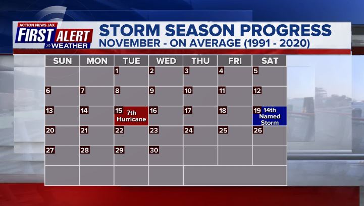
Low pressure - ‘98-L’ started to develop over the SW Atlantic north of Puerto Rico & was upgraded to subtropical storm “Nicole” early Mon., the 14th named storm of the Atlantic season which is right on avg. & close to the Nov. 19 avg. of the occurrence of the 14th named storm. Nicole transitioned to a tropical storm (purely warm core) by midday Tue. & then reached hurricane (Cat. 1) strength a bit before 6pm Wed., the 7th hurricane of the Atlantic season which happens to be right at the seasonal average which - on avg. - occurs on Nov. 15th. Nicole’s official landfall was at 3am EST on the Fl. east coast near North Hutchinson Island just south of Vero Beach as a Cat. 1 hurricane with sustained winds near 75 mph & a central pressure near 981 mb / 28.97″. Nicole was downgraded to a tropical storm about 1 hour later near 4am EST... & to a tropical depression Thu. evening.
* This year ties the record set in 2001 for the most Atlantic hurricane formations in November, at three.
* Nicole is the second-latest hurricane ever to hit the continental United States, after only Hurricane Kate, which made landfall in 1985 along the Florida Panhandle as a Category 2 hurricane the week of Thanksgiving.
* It is the latest recorded landfall ever for a hurricane on the east coast of Florida.
Given the very warm water from Fl. to the Bahamas in addition to an upper ridge building near & north of the storm while - at the same time - an upper level trough that helped spawn Nicole weakens & moves away, Nicole managed to reach hurricane strength before the Fl. landfall early Thu. Nicole turned more west & southwest then veered more west then northwest, even N/NW at times. At the same time, another upper trough is moving into the U.S. Lower 48 helping to create the alleyway from Fl. up the eastern seaboard as the brief ridge shifts east over the Atlantic. Nicole should dissipate over the Central Appalachians by Fri. night.


Radar imagery courtesy S. Florida Water Management District (purple line is the forecast track for “Nicole”):


Water vapor loop shows pockets of dry air (dark blue) across portions of the Atlantic Basin along with a lot of “swirls” (low pressure) along with “bands” of higher moisture near & ahead of fronts - common as we get deeper into autumn. ‘Nicole’ will be surrounded by a good deal of dry air this week.


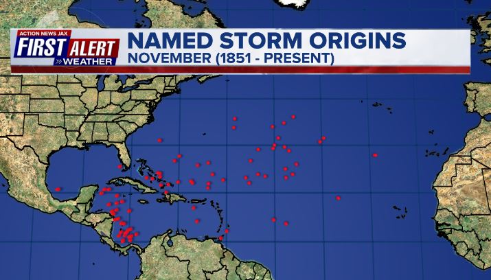
November tropical cyclone origins:
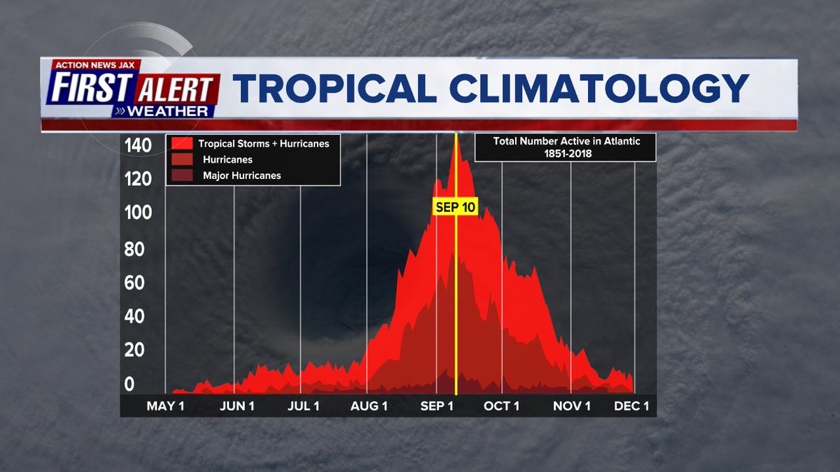
Averages below based on climatology for the Atlantic Basin through November:
Wind shear:


Saharan dust spreads west each year from Africa by the prevailing winds (from east to west over the Atlantic). Dry air - yellow/orange/red/pink. Widespread dust is indicative of dry air that can impede the development of tropical cyclones. However, sometimes “wanna’ be” waves will just wait until they get to the other side of - or away from - the plume then try to develop if other conditions are favorable. In my personal opinion, way too much is made about the presence of Saharan dust & how it relates to tropical cyclones. In any case, we’ve had several large dust plumes spread west to the Caribbean & Gulf with the peak of Saharan dust typically in June & July.

2022 names..... “Owen” is the next name on the Atlantic list (names are picked at random by the World Meteorological Organization... repeat every 6 years). Historic storms are retired [Florence & Michael in ’18... Dorian in ’19 & Laura, Eta & Iota in ‘20 & Ida in ‘21]). In fact, this year’s list of names is rather infamous with “Charley”, “Frances”, “Jeanne” & “Ivan” retired from the ‘04 list (all hit Fl.) & “Matthew” was retired in 2016. The WMO decided - beginning last year - that the Greek alphabet will be no longer used & instead there will be a supplemental list of names if the first list is exhausted (has only happened three times - 2005, 2020 & 2021). The naming of tropical cyclones began on a consistent basis in 1953. More on the history of naming tropical cyclones * here *.


East Atlantic:


Mid & upper level wind shear (enemy of tropical cyclones) analysis (CIMMS). The red lines indicate strong shear:

Water vapor imagery (dark blue indicates dry air):

Deep oceanic heat content over the Gulf, Caribbean & deep tropical Atlantic:

Sea surface temp. anomalies:


SE U.S. surface map:

Surface analysis centered on the tropical Atlantic:

Surface analysis of the Gulf:

Caribbean:

GFS wave forecast at 48 & 72 hours (2 & 3 days):


Atlantic Basin wave period forecast for 24, 48 & 72 hours respectively:


The East Pacific:


West Pacific:

Global tropical activity:


Cox Media Group
:quality(70)/cloudfront-us-east-1.images.arcpublishing.com/cmg/SKX4RKW645ERTATCLA4V2FVRKQ.png)
:quality(70)/cloudfront-us-east-1.images.arcpublishing.com/cmg/T2NL5CTMAFBI3NPDTOZHOVFLF4.jpg)
:quality(70)/cloudfront-us-east-1.images.arcpublishing.com/cmg/VFGNOWDMQRFUNDZYHRTIPEQYYQ.jpg)
:quality(70)/cloudfront-us-east-1.images.arcpublishing.com/cmg/SHM5VKGXUVFSNEJL6Z5QFC5VQY.jpg)
:quality(70)/cloudfront-us-east-1.images.arcpublishing.com/cmg/2YWEIUHK2VERFHXNEGODN4VA5Q.png)
:quality(70)/cloudfront-us-east-1.images.arcpublishing.com/cmg/2CGJT3GSNDDJNNMXR66ICDYS6A.jpg)
:quality(70)/cloudfront-us-east-1.images.arcpublishing.com/cmg/DKQZ7HGZE5U3NSKQUTLJYNMBXU.jpg)
:quality(70)/cloudfront-us-east-1.images.arcpublishing.com/cmg/K4W6X4YQR6V2BG6CP3RLVRV2BE.jpg)
 Sign Up

