:quality(70)/cloudfront-us-east-1.images.arcpublishing.com/cmg/4BY52YP3URHB3CBG6342FEUNGQ.jpg)
JACKSONVILLE, Fla. — “Talking the Tropics With Mike” - latest updates * here *.
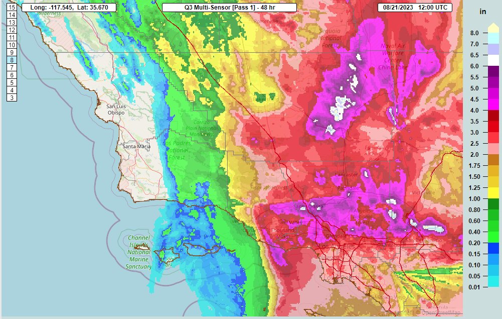
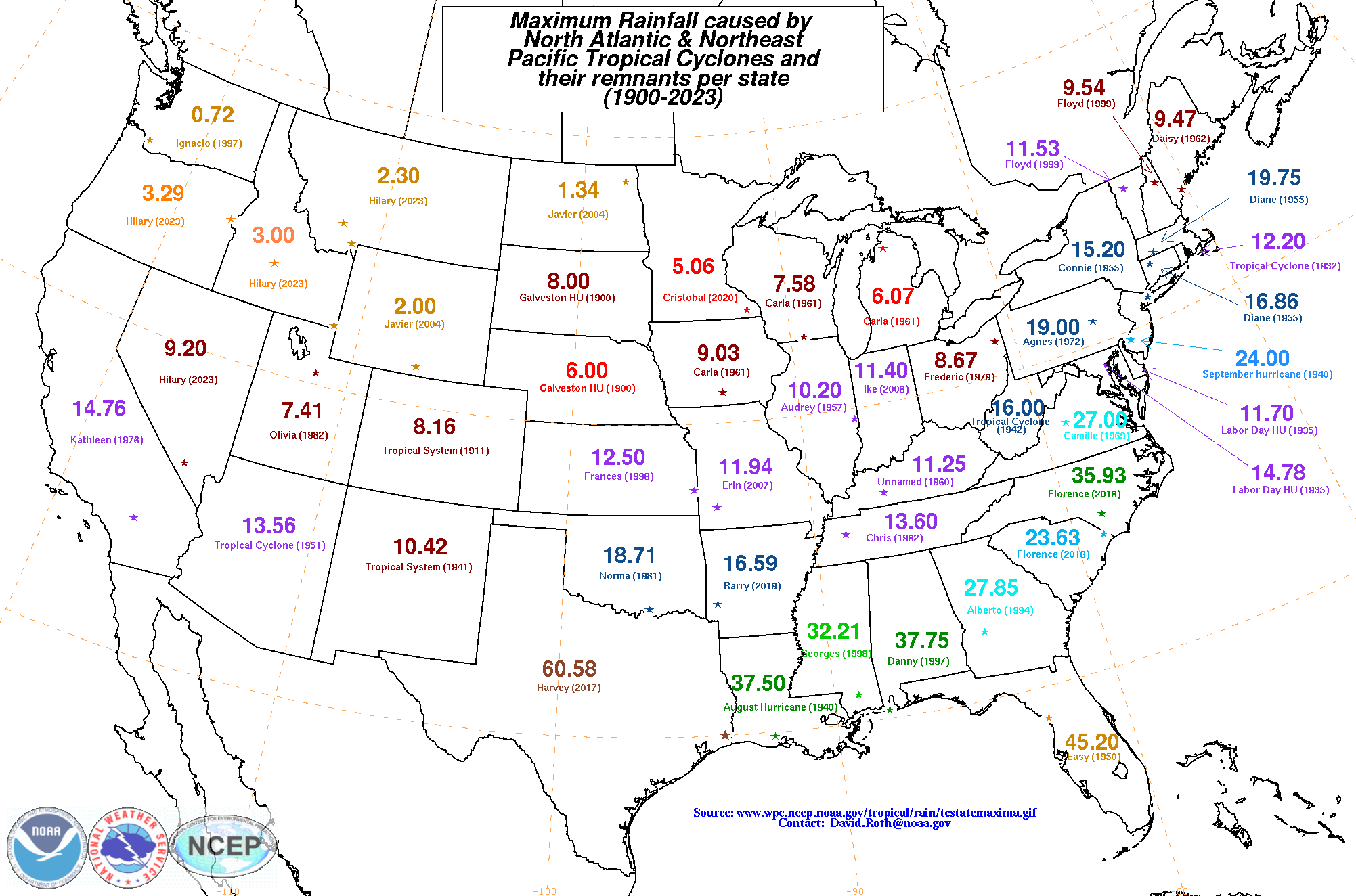
Hurricane Hilary hit the Baja of California hard then moved into California as a tropical storm dumping flooding rain & causing as much as 7-9 billion dollars worth of damage (early estimates). Realize while rare, there have been other tropical systems that have moved into California including “Kathleen” in 1976 & a tropical storm in 1939. Both years - like this year - were El Nino (warming of the equatorial Pacific) years. Much more common is tropical moisture pushing northward into the Southwest U.S. from more distant tropical systems over the E. Pacific late in the summer into early autumn. Some desert locations had their annual rainfall in less than 48 hours as Hilary raced northward.
Satellite video of #HurricaneHilary's journey to the North American west coast from August 16th - 21st 🛰️ pic.twitter.com/sb3BuCRCZK
— NWS Los Angeles (@NWSLosAngeles) August 22, 2023
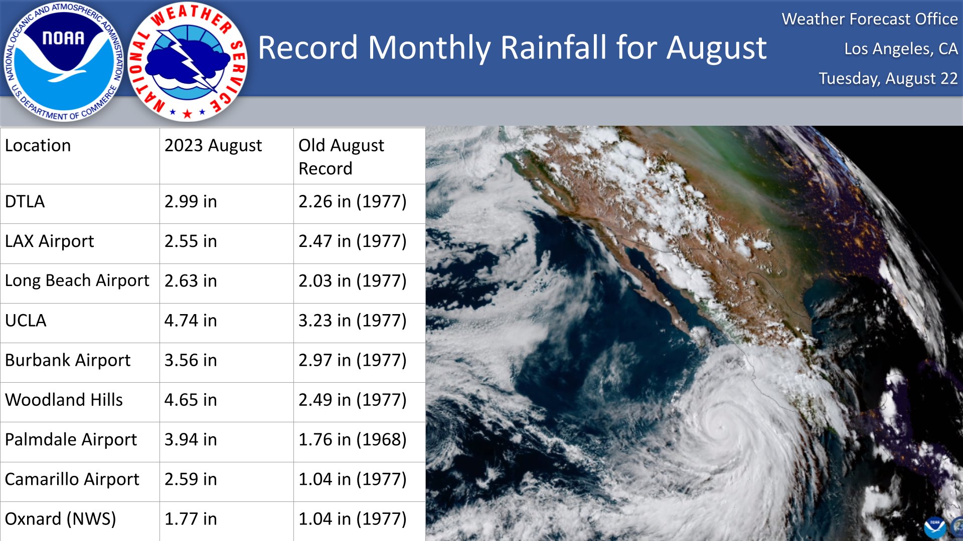
Southern California rainfall from Hilary centered on Los Angeles:
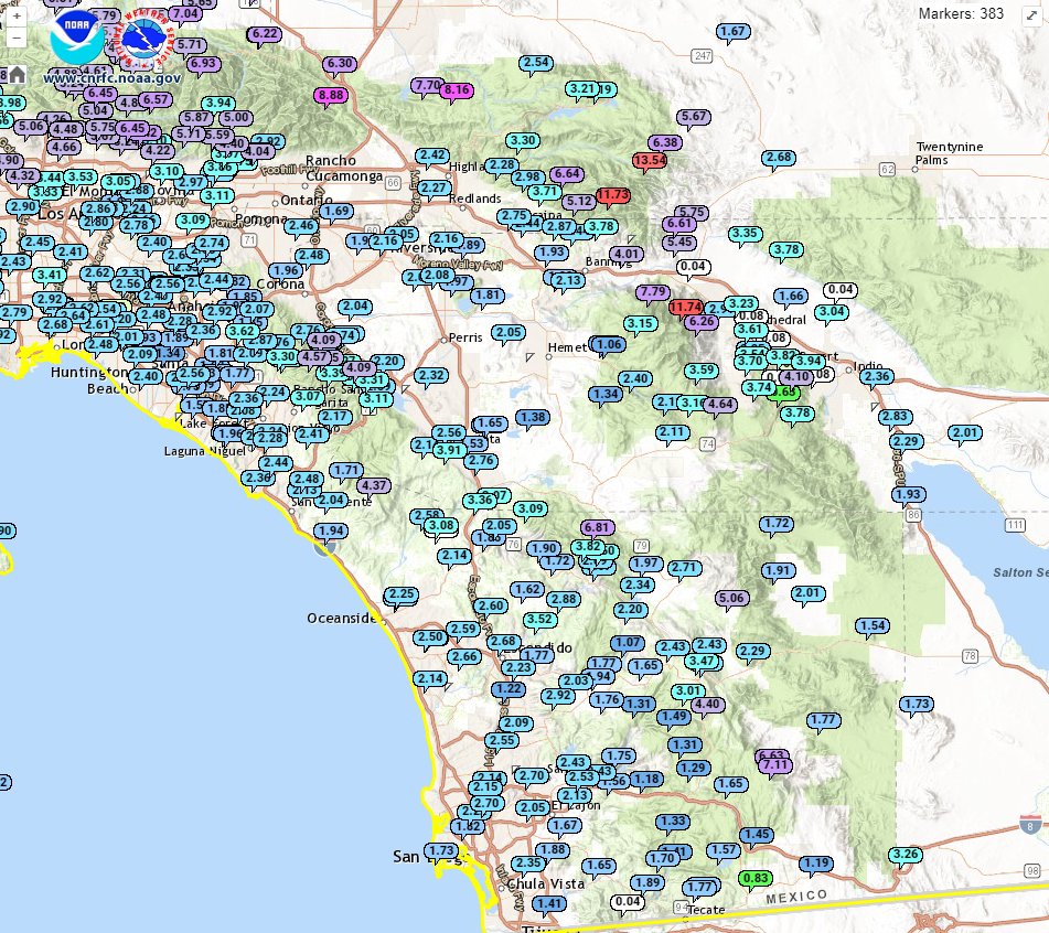
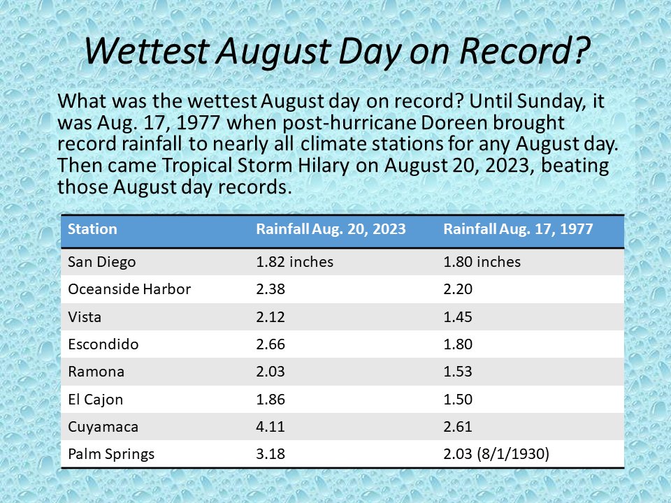
Far Southern California rainfall centered on San Diego:
Hilary set new max state rainfall records by a tropical cyclone for Nevada (9.20″), Idaho (3.00″) & Montana(!) (2.30″)
:quality(70)/cloudfront-us-east-1.images.arcpublishing.com/cmg/UPTDGXFE3VD2HAPVYIA3GF7A2U.jpg)
:quality(70)/cloudfront-us-east-1.images.arcpublishing.com/cmg/2HSVYVSXNNHZNFJZBETLQT6IQY.jpg)
:quality(70)/cloudfront-us-east-1.images.arcpublishing.com/cmg/RWGPKVTA7ZD73CHEVTW4W34FHY.jpg)
:quality(70)/cloudfront-us-east-1.images.arcpublishing.com/cmg/I454JGAQLVHFVEGXWFDP3XZVVA.jpg)
:quality(70)/cloudfront-us-east-1.images.arcpublishing.com/cmg/XH4B3TRSQ5ETJCB466MV7PLQQE.jpg)
:quality(70)/cloudfront-us-east-1.images.arcpublishing.com/cmg/WFH5DIWB2FHPXOD6LHBMVBQYUA.png)
:quality(70)/cloudfront-us-east-1.images.arcpublishing.com/cmg/CBMTXIU7ZNCEREV5VGIKGLZ5RY.jpg)
:quality(70)/cloudfront-us-east-1.images.arcpublishing.com/cmg/VWUCFO5WQ5DI3MAZ55F5XTXNY4.jpg)
:quality(70)/cloudfront-us-east-1.images.arcpublishing.com/cmg/WTO24H462BHK7NYJVYUUBKGY6U.jpg)
:quality(70)/cloudfront-us-east-1.images.arcpublishing.com/cmg/2RRCDK76YBFTVAGC5R4IEKMCNU.jpg)
:quality(70)/cloudfront-us-east-1.images.arcpublishing.com/cmg/N5MGBCIW7NEVBA4CPXVLIAEZ4Y.jpg)
:quality(70)/cloudfront-us-east-1.images.arcpublishing.com/cmg/4ZENG22ROZHSPIKGJIOTQNHA3Y.jpg)
:quality(70)/cloudfront-us-east-1.images.arcpublishing.com/cmg/OAEEA6HTDFE5ZJRXSE3HJL5CHI.jpg)
:quality(70)/cloudfront-us-east-1.images.arcpublishing.com/cmg/DKOO3O3KZFDWHNFAGU5WEY5DJI.jpg)
:quality(70)/cloudfront-us-east-1.images.arcpublishing.com/cmg/MVGO35WT3VEVFOMIXXM5TXIHSA.jpg)
:quality(70)/cloudfront-us-east-1.images.arcpublishing.com/cmg/MMWZWPBU3JCF7AYPIUXSRAJO6I.jpg)
:quality(70)/cloudfront-us-east-1.images.arcpublishing.com/cmg/54MUYNDWARBSZAV6WGTFNEBULY.jpg)
:quality(70)/cloudfront-us-east-1.images.arcpublishing.com/cmg/5HPLD2IZMRBQJLFS4HVXKOVP3U.jpg)
:quality(70)/cloudfront-us-east-1.images.arcpublishing.com/cmg/C5VEW3PLMZE6XL6ZISQFMQAFFU.jpg)
:quality(70)/cloudfront-us-east-1.images.arcpublishing.com/cmg/B5B7GOMUVJEIRABVP2CTRGZP6M.jpg)
:quality(70)/cloudfront-us-east-1.images.arcpublishing.com/cmg/JAP6SGSC2BHJFPDFBF7MDGCZEU.jpg)
:quality(70)/cloudfront-us-east-1.images.arcpublishing.com/cmg/DUORRCD4IZGMHJIMWVARB5OFNE.jpg)
:quality(70)/cloudfront-us-east-1.images.arcpublishing.com/cmg/6AEIHKHRKJCGVBRIWKTVNMMYLQ.jpg)
:quality(70)/cloudfront-us-east-1.images.arcpublishing.com/cmg/QFYEANBP6RBGYKWAPCW56AJCBM.jpg)
:quality(70)/cloudfront-us-east-1.images.arcpublishing.com/cmg/LVE56OHN23MJFEIEXPAALW5DPI.jpg)
:quality(70)/cloudfront-us-east-1.images.arcpublishing.com/cmg/S2YQ4CSEYX4KCHZF2DQNA4O5XU.jpg)
:quality(70)/cloudfront-us-east-1.images.arcpublishing.com/cmg/N3MOSN7L5VDMJEVUJ6J3Y4LHTY.jpg)
:quality(70)/cloudfront-us-east-1.images.arcpublishing.com/cmg/S3POE3RBTRGA6LB2SZRJHL64DY.jpg)
:quality(70)/cloudfront-us-east-1.images.arcpublishing.com/cmg/OHGSV4SS3GP36MWJSZW74J3V3U.jpg)
:quality(70)/cloudfront-us-east-1.images.arcpublishing.com/cmg/3H7XBIKSW276KG3KJP4NFJI36M.jpg)
:quality(70)/cloudfront-us-east-1.images.arcpublishing.com/cmg/MTL6GUFTHIJN4INCYXYYH2MNGU.jpg)
:quality(70)/cloudfront-us-east-1.images.arcpublishing.com/cmg/CDX42LEFQMAT2RFVHWULYA3R34.jpg)
:quality(70)/cloudfront-us-east-1.images.arcpublishing.com/cmg/56BEQPG4TEHR27ZKZYQBOZ6TCI.jpg)
:quality(70)/cloudfront-us-east-1.images.arcpublishing.com/cmg/Q2SRCIKDSNHPECBQYFBX5LHR6Y.jpg)
:quality(70)/cloudfront-us-east-1.images.arcpublishing.com/cmg/YOFBIM6UJXWKAAURKEXQ7O2TWI.jpg)
:quality(70)/cloudfront-us-east-1.images.arcpublishing.com/cmg/IBYSONPLOUVU4VPX26KNIOYI7A.jpg)
:quality(70)/cloudfront-us-east-1.images.arcpublishing.com/cmg/WUEZWXRNG3L22GF73Z3CDCMW4Y.jpg)
:quality(70)/cloudfront-us-east-1.images.arcpublishing.com/cmg/YPRYFVL7JXSNQOCGXEJOAUVH7M.jpg)
:quality(70)/cloudfront-us-east-1.images.arcpublishing.com/cmg/PEJOWUUI4TUBV3UJGIJU6ZPYAE.jpg)
:quality(70)/cloudfront-us-east-1.images.arcpublishing.com/cmg/OE4PN2KL66Q26DX5ALWRP2FEFE.jpg)
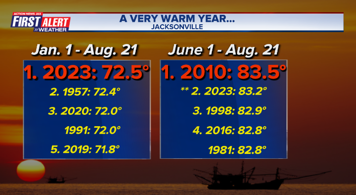
It’s felt like a very warm year & hot summer & the numbers back that up. Since the official Jacksonville thermometer has been located at JIA in 1956, the year through Aug. 21st is the warmest on record - avg. is 69.6 degrees F... & the summer so far (June/July/Aug.) has been the 2nd hottest on record - avg. is 81.4 degrees F.
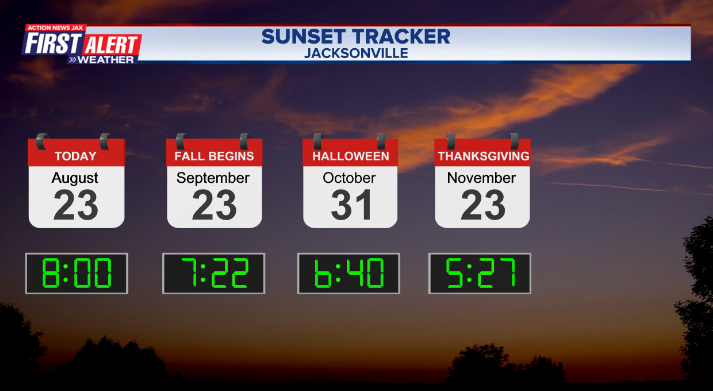
But fall is just around the corner as daylight is decreasing. As of Thu., Aug. 24, sunset will be before 8pm while sunrise will be after 7am:
:quality(70)/cloudfront-us-east-1.images.arcpublishing.com/cmg/HJ3L3HBBJBH6PB5ZFB3SVGFXSU.png)
:quality(70)/cloudfront-us-east-1.images.arcpublishing.com/cmg/SKX4RKW645ERTATCLA4V2FVRKQ.png)
:quality(70)/cloudfront-us-east-1.images.arcpublishing.com/cmg/SCWUKX27NRFXVFR2KCQYQ3ZPQY.jpg)
:quality(70)/cloudfront-us-east-1.images.arcpublishing.com/cmg/K6OREARNAFCUVNXWZV2C57LXIU.jpg)
:quality(70)/cloudfront-us-east-1.images.arcpublishing.com/cmg/V7JDMMD6JJEEHIL6C7OSLV3ABU.png)
:quality(70)/cloudfront-us-east-1.images.arcpublishing.com/cmg/DZTWARDVNYP4IYRLG5QAJBNZE4.jpg)
:quality(70)/cloudfront-us-east-1.images.arcpublishing.com/cmg/SG7PSJXKDDTMAVLUPLB3YAYUFI.jpg)
:quality(70)/cloudfront-us-east-1.images.arcpublishing.com/cmg/GT4J3GMNQINWSB2AQ3B43HIQYM.jpg)
 Sign Up

