
JACKSONVILLE, Fla. — Updated every day through the hurricane season: “Talking the Tropics With Mike”...
September averages for JIA:

September night skies (courtesy Sky & Telescope):
Sept. 5 (evening): The Moon, one day before last quarter, trails the Pleiades by less than 5° as they rise.
Sept. 10 (dawn): High in the east the waning crescent Moon hangs some 4° below Pollux. Castor completes the trio.
Sept. 11 (dawn): Face east to see the thin lunar crescent in Cancer some 4° left of the Beehive Cluster (M44).
Sept. 13 (dawn): The almost-new Moon and Regulus, Leo’s brightest star, are about 4½° apart low in the east.
Sept. 16 (dawn): For the next two weeks, look for Mercury low in the east about 30 minutes before sunrise.
Sept. 20 (dusk): The waxing crescent Moon is 4° to the lower right of Antares as the pair sink toward the horizon.
Sept. 22 (dawn): Mercury appears farthest from the Sun (18°) in the eastern sky.
Sept. 23: Autumn begins in the Northern Hemisphere at the equinox, 2:50 a.m. EDT.
Sept. 26 (evening): The waxing gibbous Moon gleams some 3° below Saturn.
Moon Phases
Last Quarter Sept. 6 6:21 p.m. EDT
New Moon Sept. 14 9:40 p.m. EDT
First Quarter Sept. 24 3:32 p.m. EDT
Full Moon Sept. 29 5:58 a.m. EDT (Harvest Moon)
The fourth “major” (Cat. 3 or stronger) hurricane in the last 6 years has hit Florida as Cat. 3 Idalia came ashore Wed., Aug. 30th on the Big Bend of Florida near Keaton Beach. A breakdown of the week that was dominated by a Gulf of Mexico hurricane:

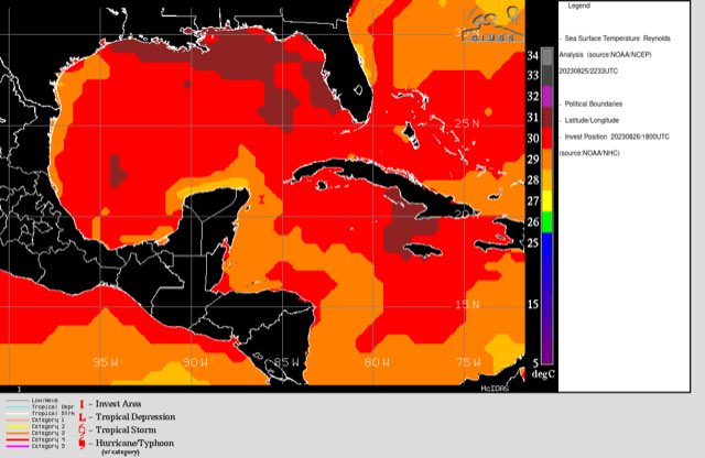
Forecast models began hinting at possible tropical development over or near the Gulf as early as the weekend of Aug. 19-20th. The potential development did match the pattern as a series of tropical waves near Central America - essentially a monsoon trough - had been established for some time. One of those waves/disturbances “broke away” to the north eventually becoming tropical cyclone “Idalia”.
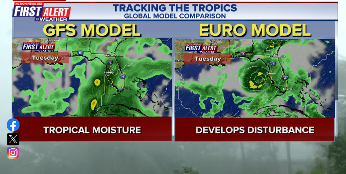
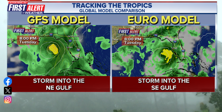
The American GFS model struggled early on with even “finding” a tropical cyclone often times showing little more than a surface trough of low pressure accompanied by a “slug” of tropical moisture. The European model, on the other hand (along with the Canadian model), was reasonably consistent in showing tropical development though - admittedly did struggle at times with track & - to some degree - with intensity. Once virtually all the forecast models caught on... the GFS did very well with track (was generally the farthest west over the Central or Eastern Panhandle) & was often quite strong... while the European model was generally too far east. The UKMET was consistently too weak but decent on landfall location. The image below is from Thu., Aug. 24th & shows the stark difference between the GFS & European models. The GFS finally caught on by Fri., the 25th - the 2nd image below.
Credit goes to the NHC which outlined the area of concern early (Wed., Aug. 30) & consistently “painted” a track northeast across the Eastern Gulf. In fact, the first track forecast issued once the tropical cyclone formed - Sat., Aug. 26th - was missed by a mere 7 miles upon landfall!

We began Action News Jax with the forecast tropical development at 10 & 11pm Wed., Aug. 23 - a week before landfall. I had been addressing the potential development in the days prior in “Talking the Tropics With Mike”. Here’s the tweet I posted that Wed. evening:
#firstalertwx - & there it is... "the cat is out of the bag" - we'll have to keep a close eye on the Gulf of Mexico next week for tropical development. Still a lot of question remarks but reasonable confidence there will be "something" & likely headed some semblance of north pic.twitter.com/cO4KEuyqdG
— Mike Buresh (@MikeFirstAlert) August 24, 2023
I sent an email to our newsroom managers the next day outlining my concern for a hurricane the following week.
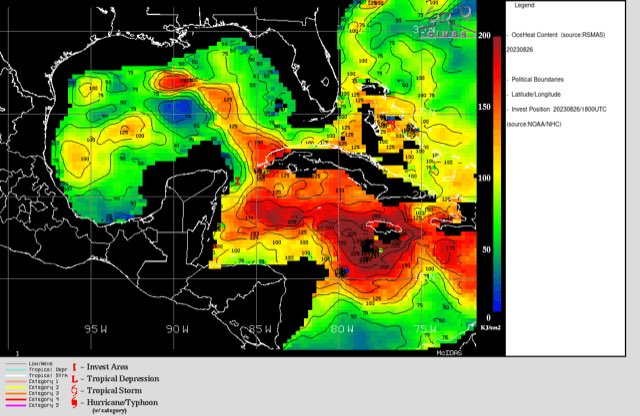
By Friday & the weekend, it was obvious a tropical cyclone would develop & was highly like to impact Florida. There were conflicting signals on intensity as wind shear was high over the Northern Caribbean/far Southern Gulf but decreased across the Northern Gulf. In addition, Idalia would be moving in the direction of the shear vector (toward the NE) which is generally not as detrimental for tropical cyclones. Even more concerning was very warm deep ocean water. A weak upper level trough of low pressure over the Eastern U.S. aided with upper level diffluence which often favors an intensifying tropical cyclone. The trough also maintained an alleyway for Idalia to follow northeast.
If there was a saving grace with Idalia, it was a timely eyewall replacement cycle about 2-3 hours before landfall which stopped the intensification process & caused some weakening (Cat. 3 instead of 4) at landfall. History shows us that the winds of a weakening landfalling tropical cyclone are often lower than the estimated peak winds by aircraft vs. a strengthening hurricane right up to landfall (Cat. 5 Michael for example in 2018). Eyewall replacement cycles are rain bands outside the original eyewall that strengthen. Eventually energy is transferred from the original eyewall to the new outer eyewall and the original eyewall then weakens & eventually dissipates. During this process, the hurricane & its winds usually slacken some. If & when the eyewall replacement is completed, re-intensification can start anew. But Idalia did not have the opportunity to complete the cycle before moving over land. The image below shows a simulated eyewall replacement using radar imagery:

The Jacksonville N.W.S. has released an Idalia summary for NE Fl. & SE Ga. * here *.
Southeast U.S. Idalia rainfall:
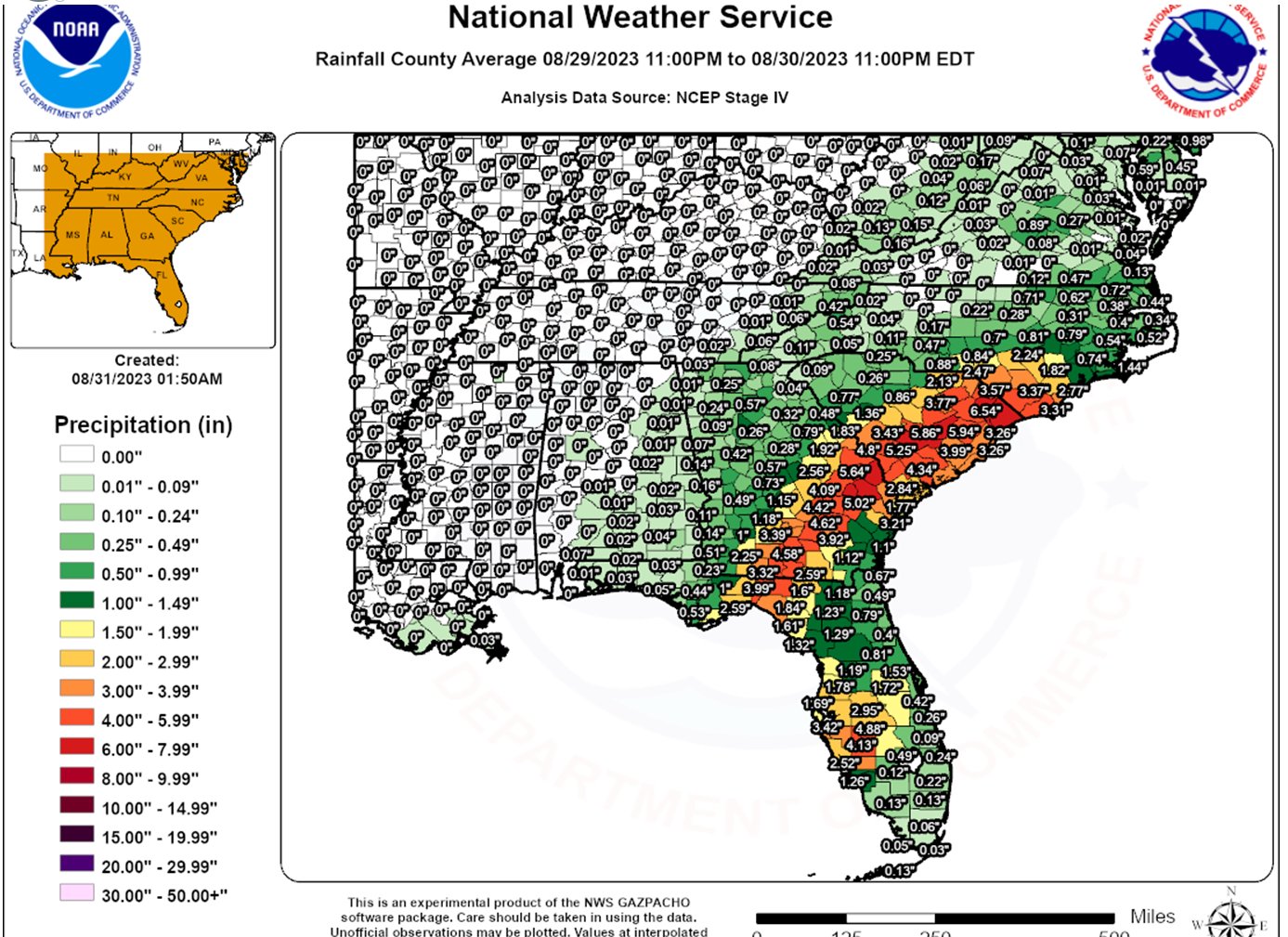
Doppler estimated rainfall from Idalia. As is usually the case, once Idalia made landfall, dry continental air quickly wrapped around the circulation resulting in far less rainfall to the south & southeast of the center:
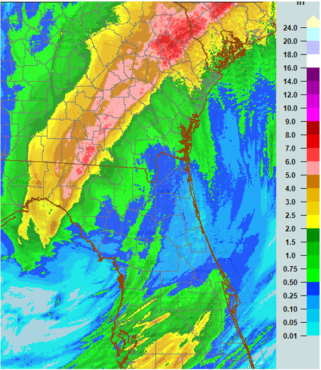
North Fl. Idalia rainfall:
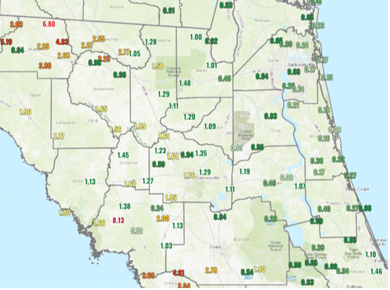
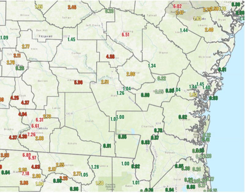
South Georgia Idalia rainfall:
Peak wind gust from Idalia across NE Fl. & SE Ga.:


Sea level pressure dropped to the 2nd lowest on record for August at JIA since 1951 (996.1mb/29.42″):

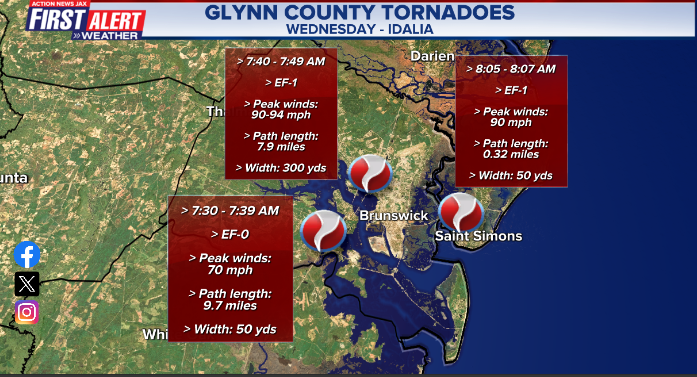
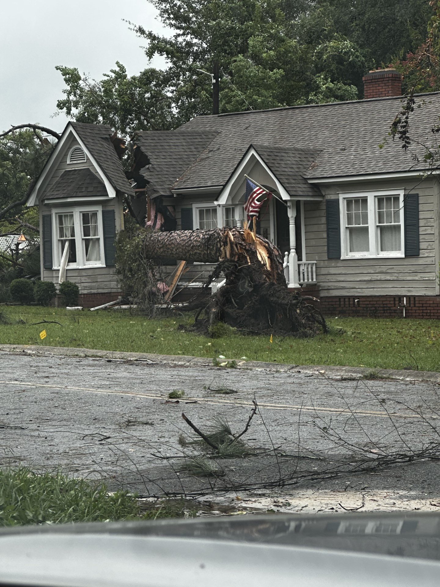
3 tornadoes were confirmed in the Action News Jax viewing area - all in Glynn Co., Ga. & all occurring between 7:30 & 8:15am Wed.:
Waycross, Ga.:

Lake City, FL.:
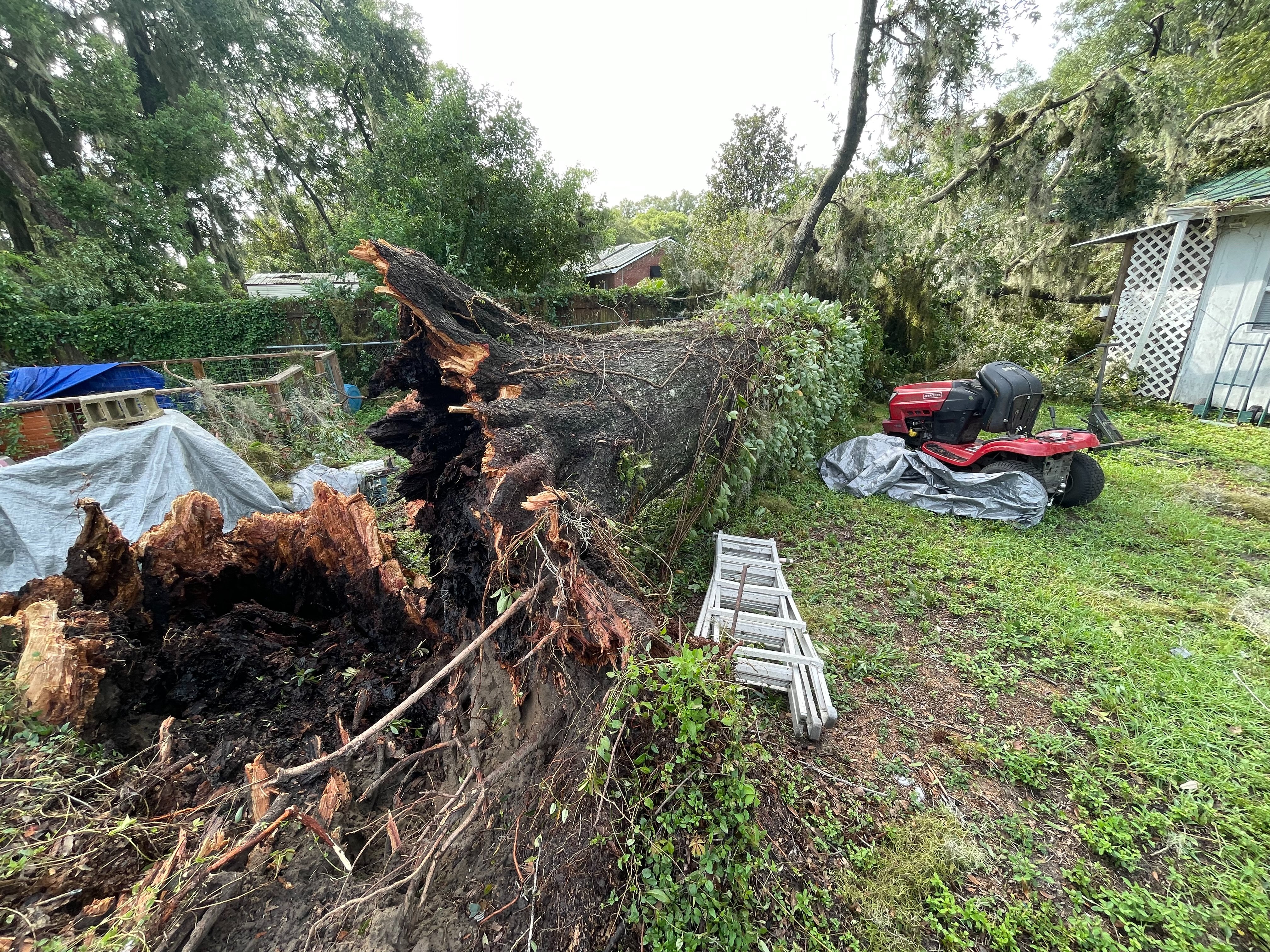
Waycross, Ga.:
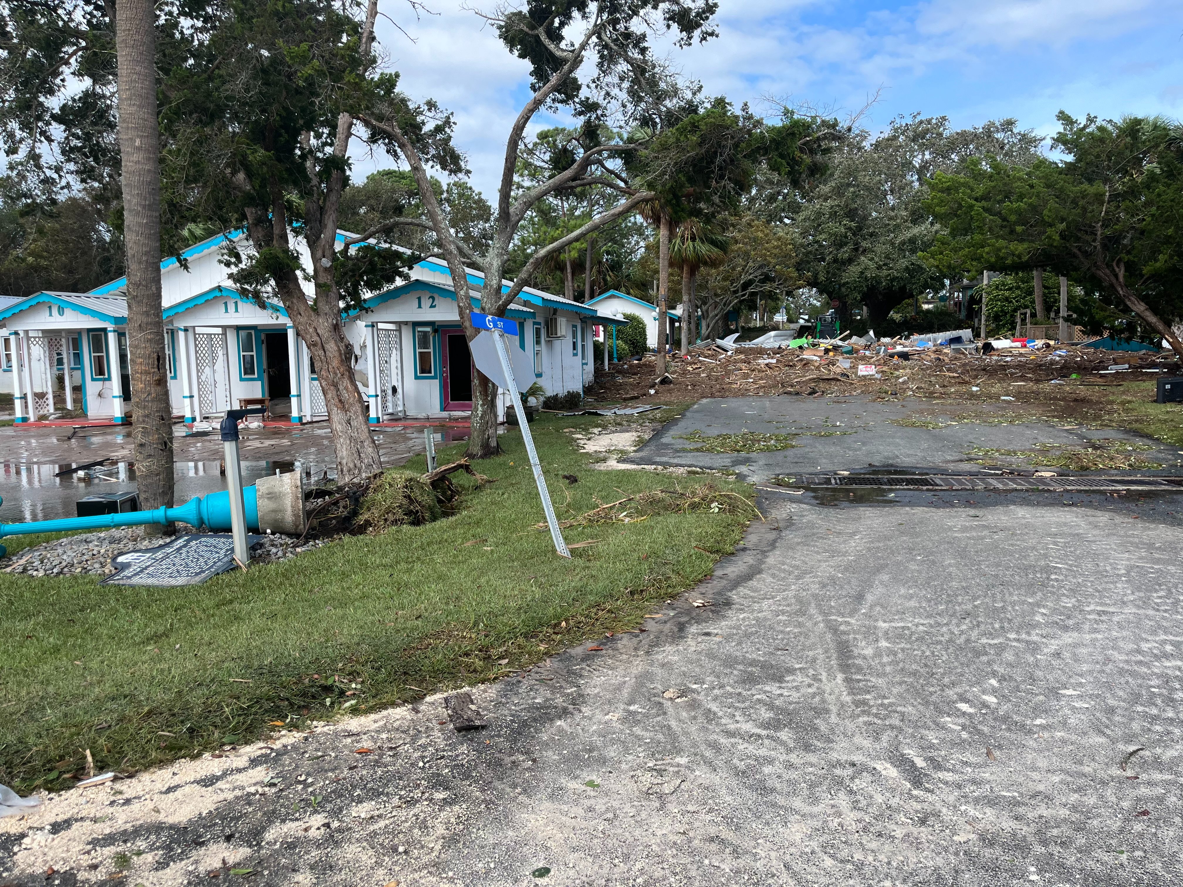
Cedar Key storm surge debris:
#firstalertwx tree damage along I-10 NW Fl from #HurricaneIdalia @ActionNewsJax @WOKVNews pic.twitter.com/OpLnO9M5x5
— Mike Buresh (@MikeFirstAlert) September 1, 2023
😮JAW-DROPPING FOOTAGE 😮 Hurricane Idalia's destructive storm surge washed away this home in Horseshoe Beach, Fla.
— WeatherBug (@WeatherBug) August 31, 2023
Credit: J Brennon Garrett via Storyful pic.twitter.com/uaDPcA4yZT
The sea surface temperature cooling footprint left behind by #Franklin & #Idalia is one of the more impressive I've seen. Widespread sub 26 C & a chunk taken out of the record +SSTAs in west part of the NATL basin.
— Philippe Papin (@pppapin) September 4, 2023
Something to watch if additional TCs traverse this region soon. pic.twitter.com/WhgnjnErUh


 Sign Up


