
Jacksonville, Fl. — The “Buresh Bottom Line”: Always be prepared!.....First Alert Hurricane Preparation Guide... City of Jacksonville Preparedness Guide... Georgia Hurricane Guide.
STAY INFORMED: Get the * FREE * First Alert Weather app
FREE NEWS UPDATES, ALERTS: Action News Jax app for Apple | For Android
WATCH “Preparing for the Storm”
WATCH “The Ins & Outs of Hurricane Season”
READ the First Alert Hurricane Center “Survival Guide”
LISTEN & WATCH “Surviving the Storm” - WOKV Radio & Action News Jax
***** ALWAYS CHECK & RE-CHECK THE LATEST FORECAST & UPDATES! *****
REMEMBER WHEN A TROPICAL STORM OR HURRICANE IS APPROACHING: Taping windows is *not* recommended & will not keep glass from breaking. Instead close curtains & blinds.
Realize the forecast cone (”cone of uncertainty”) is the average forecast error over a given time - out to 5 days - & *does not* indicate the width of the storm &/or where damage that might occur.

Impacts for Jacksonville/NE Fl./SE Ga. from the remnants of “Cindy”: None.
The combination of remnants from Cindy & especially a tropical wave to the south & east of Bermuda continues to produce disorganized showers & t’storms being undercut by strong wind shear out of the west/southwest. A slow drift to the north can be expected through the weekend with a low chance for further development. There will be some interaction with an upper level trough next week which may give the disturbance a bit of a “boost”. But for the most part it looks like the “disturbed weather” will stay out to sea.
There is a low latitude tropical wave about half across the Atlantic. There is strong shear ahead of this wave not to mention proximity to land as the wave rolls west/northwest. It appears this wave may quickly cross Central America leading to tropical development on the Pacific side that *could* eventually impact Western Mexico.


Water vapor loop (dark blue/yellow is dry mid & upper level air):


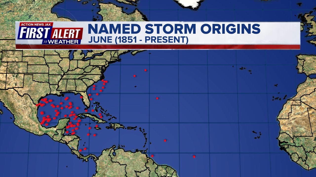
June tropical cyclone origins:
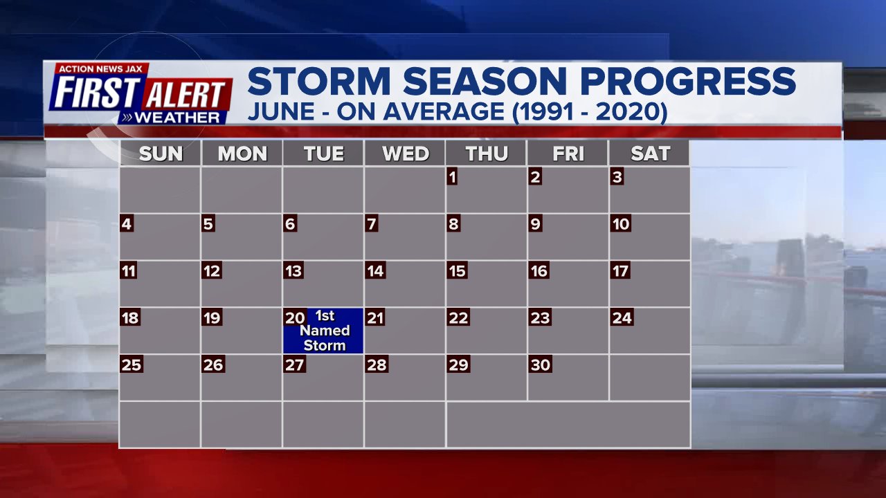
Averages below based on climatology for the Atlantic Basin for June:

Wind shear:


Saharan dust spreads west each year from Africa by the prevailing winds (from east to west over the Atlantic). Dry air - yellow/orange/red/pink. Widespread dust is indicative of dry air that can impede the development of tropical cyclones. However, sometimes “wanna’ be” waves will just wait until they get to the other side of - or away from - the plume then try to develop if other conditions are favorable. In my personal opinion, way too much is made about the presence of Saharan dust & how it relates to tropical cyclones. In any case, the peak of Saharan dust typically is in June & July.

2023 names..... “Don” is the next name on the Atlantic list (names are picked at random by the World Meteorological Organization... repeat every 6 years). Historic storms are retired [Florence & Michael in ’18... Dorian in ’19 & Laura, Eta & Iota in ‘20, Ida in ‘21 & Fiona & Ian in ‘22]). In fact, this year’s list of names is rather infamous with “Katrina”, “Rita” & “Wilma” retired from the ‘05 list & “Harvey”, “Irma”,“Maria” & “Nate” from the ‘17 list. The WMO decided - beginning in 2021 - that the Greek alphabet will be no longer used & instead there will be a supplemental list of names if the first list is exhausted (has only happened three times - 2005, 2020 & 2021). The naming of tropical cyclones began on a consistent basis in 1953. More on the history of naming tropical cyclones * here *.


East Atlantic:


Mid & upper level wind shear (enemy of tropical cyclones) analysis (CIMMS). The red lines indicate strong shear:

Water vapor imagery (dark blue indicates dry air):

Deep oceanic heat content over the Gulf, Caribbean & deep tropical Atlantic. The brighter colors will expand rather dramatically by Aug./Sept./Oct.:

Sea surface temp. anomalies:


SE U.S. surface map:

Surface analysis centered on the tropical Atlantic:

Surface analysis of the Gulf:

Caribbean:

GFS wave forecast at 48 & 72 hours (2 & 3 days):


Atlantic Basin wave period forecast for 24, 48 & 72 hours respectively:


East Pacific:
The E. Pacific has - as expected - become much more active after one of the latest starts (first named storm) in at least the last 50 years. While Adrian will remain out over open water & dissipate within the next couple days... Beatriz has grazed the southwest coast of Mexico as a Cat. 1 hurricane with heavy rain, strong winds & rough surf. Interaction with land is causing weakening which is expected to continue over the far E. Pacific with little re-generation expected at this point.
A Tropical Storm WARNING: Manzanillo to Punta Mita Mexico A Tropical Storm WATCH: North of Punta Mita to San Blas Mexico Las Islas Marias


West Pacific:

Global tropical activity:


Cox Media Group


 Sign Up


