:quality(70)/cloudfront-us-east-1.images.arcpublishing.com/cmg/WW5AJL3ARQUGDQMAQUNSFX4CLE.jpg)
Jacksonville, Fl. — The “Buresh Bottom Line”: Always be prepared!.....First Alert Hurricane Survival Guide... City of Jacksonville Preparedness Guide... Georgia Hurricane Guide.
STAY INFORMED: Get the * FREE * First Alert Weather app
FREE NEWS UPDATES, ALERTS: Action News Jax app for Apple | For Android
WATCH “Preparing for the Storm”
WATCH “The Ins & Outs of Hurricane Season”
READ the First Alert Hurricane Center “Survival Guide”
LISTEN & WATCH “Surviving the Storm” - WOKV Radio & Action News Jax
***** ALWAYS CHECK & RE-CHECK THE LATEST FORECAST & UPDATES! *****
REMEMBER WHEN A TROPICAL STORM OR HURRICANE IS APPROACHING: Taping windows is *NOT* helpful & will not keep glass from breaking.
Realize the forecast cone (”cone of uncertainty”) is the average forecast error over a given time - out to 5 days - & *does not* indicate the width of the storm &/or damage that might occur.

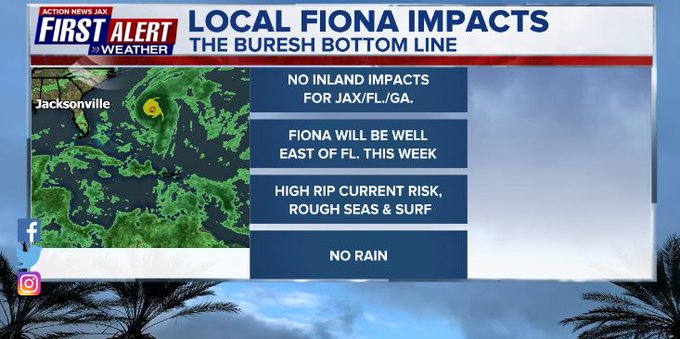
** No direct *inland* impacts expected from Fiona for Jacksonville/NE Fl./SE Ga.... beaches to be affected by easterly swells, rough seas/surf & a high rip current risk mid through late week.... **
Atlantic Basin:
Tropical wave - ‘96-L’ was upgraded to tropical depression #7 Wed. morning then to tropical storm “Fiona” Wed. evening & to a hurricane Sun. morning with a Cat. 1 (85 mph winds) landfall Sunday afternoon about 3:20pm EDT along the southwest coast of Puerto Rico near Punta Tocon followed by another landfall (Cat. 1/90 mph winds) early Mon. at 3:30am EDT along the coast of the Dominican Republic near Boca de Yuma.
Fiona has been battling a narrow - but significant - 30-40 mph - band of westerly shear to its immediate west & northwest but has still managed to organize. Storm bands started wrapping around the center Fri. evening as the storm organized & subsequently strengthened. Upper level outflow has improved dramatically allowing for “ventilation” & outside of land interaction, Fiona should be steadily strengthening over the next several days. Of note - the center moving a little south of due west into the face of the shear - as was the case Wed./Thu. & parts of Fri. - has led to eventually powerful hurricanes that had a similar trend. It does seem Fiona is destined to become the first major (Cat. 3+) hurricane of the season for the Atlantic Basin. After a jog north Sat., & jog west Sunday evening, Fiona has resumed a more west/northwest course with a move to near or over the Dominican Republic Mon. followed by a sharper turn north to near & just east of the SE Bahamian Islands Tue.
FIONA SUMMARY/IMPACTS:
* Puerto Rico/U.S. Virgin Islands/nearby Caribbean islands: Heaviest rain, strongest winds & most severe seas into Mon. with improving conditions by Mon. night-Tue.
* Most intense impacts for Hispaniola through Mon. night. Strongest winds will impact Dominican Republic along with flooding rains/mudslides... Haiti will be subject to some heavy rain & flooding but winds look to be much less & rainfall not as heavy as to the east.
* Impacts to the Southeast Bahamas Mon. night through Tue. night, especially the Turks & Caicos Islands.
* Impacts for Bermuda Thu. night/Fri.
* Possible - but still subject to change - impacts for Nova Scotia next weekend (becoming large/strong post-tropical ocean storm)
* Increasing swells/seas/surf + dangerous rip currents for virtually all of the U.S. east coast during the upcoming week (but Fiona well offshore)
Forecast models briefly trended more west Thu. but have trended back east recently which is why one should not become too obsessed with individual model runs. Some of the real time aircraft dropsonde data was used Thu. in the 18Z (2pm) GFS model run *but not* in the 00Z (8pm) model run which is probably why the GFS had a “hiccup” in the 18Z Thu. run showing a track much more west. I bemoan when real time data is not consistently used within the models as it usually causes inconsistency within the models. Either use it with reach run as long as it’s available or don’t use it at all. The good news is that Gulfstream G-IV research aircraft started consistently flying Sat. & hopefully will continue the next several days with the data gathered from the atmospheric environment in & around Fiona then can be used to initialize the GFS for each run. This would help with better initial analysis for models at the beginning of the forecast cycle which would then - in theory - give more accurate output (forecast). The good news is that both the GFS & European models have generally been initializing/starting with a reasonable & accurate depiction of Fiona & its strength/location so far. Clustering & consistency of the models has recently improved with a definite trend east of the U.S. mainland. The GFS remains a little faster & bit more east than the European model... the UKMET appears to be out to lunch.
In any case... the historically more reliable models remain in better general agreement as the GFS is back to where it’s been for days - a powerful hurricane well east of Fl. mid week & staying east of the entire east coast of the U.S. through the end of the week. The European model has certainly trended east too though still slower, but now has even joined the “party” in taking Fiona far to the east of the entire U.S. east coast. A strong upper level trough still looks like it’ll capture Fiona by next weekend bending the transitioning to a post-tropical low to the north & northwest late in the week/next weekend which has implications for Nova Scotia as the low will remain very powerful. The GFS remains more east than the European later win the week too. The UKMET model is still showing a relatively weak Fiona through the week far to the east of Fl. From an intensity standpoint in particular, the UKMET is an outlier (big time).
The westerly shear + somewhat dry air nearby have been the primary reasons for Fiona’s struggles the past several days. Having said that, Fiona still managed to produce strong & persistent convection despite less than ideal conditions. Overall environmental conditions are gradually improving near Fiona the next few days, so Fiona should maintain hurricane intensity. The big caveat into Mon. will be possible land interaction - especially the mountainous terrain of Hispaniola.
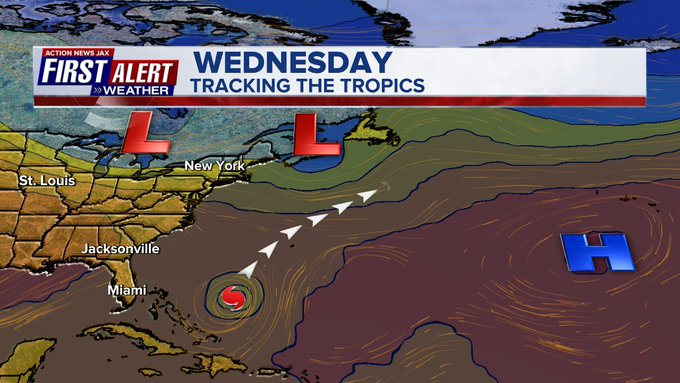
On the current official forecast track, Fiona will move near or a little east of some of the highest mountain ranges of Haiti & the Dominican Republic. It’s this part of the forecast - Hispaniola - that right now is the most critical - the “fork in the road” when it comes to strength & track once over the SW Atlantic given the track over land could disrupt Fiona’s organization some. The three most major steering influences otherwise will be: (1) the Bermuda high (clockwise circulation) which remains well to the northeast over the Atlantic... & (2) the strength of Fiona - weaker is longer to the west steered more by low level flow (trade winds)... stronger will be faster to make the turn more northwest then north (steered by mid & upper level flow)... & (3) a strong upper level trough that moves into New England & the NW Atlantic late in the week which should capture Fiona & keep the storm out to sea.
So forecast models continue to trend northward next week with Fiona which is reasonable given the now obvious alleyway that’s become well established over the W. Atlantic. There will be some stair-stepping (north then NW to north, even NE then back to the north or NW) at times as weak upper level troughs come & go through mid week before Fiona encounters the strong upper level trough in about 4-5 days. The model spread has - for the most part - narrowed considerably. One can’t overlook the GFS stability & reliability so far which takes Fiona over only far Eastern Dominican Republic with much of the circulation remaining over the Mona Passage (between Dominican Republic & Puerto Rico) while just glancing the eastern/NE coast of the Dominican Republic. This path would mimic Matthew in 2016 (in the short term!) which shot through the narrow (only about 80 miles) strait of ocean with few impacts from land.
Overall - once over the Southwest Atlantic - it looks like conditions (water temps., shear & moisture) will favor strengthening through midweek. There will still be some westerly shear, but Fiona will be moving “with” the shear + may aid from some mid & upper level ventilation courtesy the upper level trough over the NW Atlantic. While Fiona should stay far to the east of Florida & the U.S. east coast, one should check & re-check the First Alert forecast.
Another interesting forecasting tidbit... a typhoon over the W. Pacific is turning sharply to the north & northeast across Japan (track map at the bottom). This typhoon teleconnection might correlate rather well with Fiona over the W. Atlantic this week & the rather sharp turn north & - in time - northeast. This correlation is possible because of the upper level pattern - troughs (dips) & ridges (upside down U’s) in the jet stream - that often (not always) mirror each basin (Pacific & Atlantic). See maps 6 & 7 below.
So to recap: Fiona is a storm having serious impacts on the Northern Leeward & much of the Eastern Windward Islands of the Caribbean (no direct impacts to Cuba) through Monday with very heavy rain & strong winds with flooding & possible mudslides... then eventually at least some impact on some of the Bahamas Tue./Wed. - especially the Turks and Caicos Islands - followed by a move more north & - finally - north/northeast with a close pass to Bermuda Thu.-early Fri. Then there will be the bend back to the north or even a little northwest over the N & NW Atlantic late in the week.
Elsewhere... a couple of pretty strong tropical waves are over the Eastern Atlantic with at least some potential for slow development. One low over the Central Atlantic will move more north so no chance to move across the Atlantic. A more southern latitude wave just off the African coast may try to chug its way westward, at least in the short term.
Some weak low pressure is over the Western Atlantic to the east of the Carolina’s & E/NE of Jacksonville in response to an upper level trough. The low should move slowly east/southeast embedded within strong shear that will likely hinder development but there may some interaction with Fiona by mid week if the low has not already dissipated.


Spaghetti plots including the ensemble (faint lines showing all the model runs which gives an indication of the uncertainty):

The alleyway for Fiona is well established as the Bermuda high shifts east & a series of upper level troughs move to the U.S. east coast & NW Atlantic:
Mountainous terrain over especially the Central & Western portions of Hispaniola with some peaks 10,000+ feet. It looks like Fiona will miss many of the highest mountains:
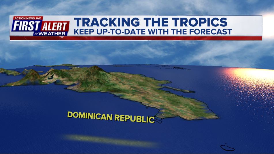
Image Courtesy: NASA/JPL/SRTMImage

The upper level (about 30,000 feet) teleconnection with troughs & ridges between the Atlantic (steering Fiona) & the Pacific (steering W. Pacific typhoons):


Despite the eye of Fiona moving away, very heavy rain bands well to the east of the center are still streaming northward across Puerto Rico where rainfall totals will exceed 2 feet on some parts of the islands!:


Water vapor loop shows some dry air near wave ‘96-L’, but it’s more moist than past days:

A zone of shear - on the order of 20-30+ mph - remains east/west just north of Fiona. Forecast models gradually take Fiona to the edge then west of the strongest shear.

Sunday morning:
#firstalertwx https://t.co/FdtG6zso0A
— Mike Buresh (@MikeFirstAlert) September 19, 2022
Friday night recon mission:
#firstalertwx #Fiona from above under the cover of darkness - Fri. night, 09/16 @ActionNewsJax @WOKVNews https://t.co/vedwUd0rHk
— Mike Buresh (@MikeFirstAlert) September 17, 2022
Thursday recon mission:
#firstalertwx recon video of #Fiona - Thu., 09/15 @ActionNewsJax @WOKVNews https://t.co/kM84hvpEVw
— Mike Buresh (@MikeFirstAlert) September 16, 2022


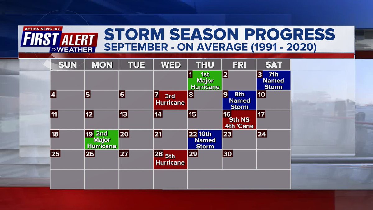
September origins:
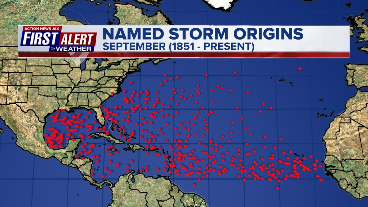
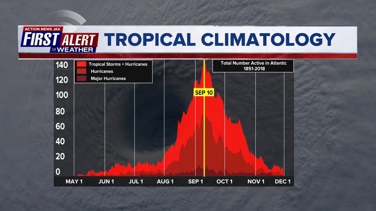
Averages below based on climatology for the Atlantic Basin through September. This season so far is well below avg.:
Wind shear:


Saharan dust spreads west each year from Africa by the prevailing winds (from east to west over the Atlantic). Dry air - yellow/orange/red/pink. Widespread dust is indicative of dry air that can impede the development of tropical cyclones. However, sometimes “wanna’ be” waves will just wait until they get to the other side of - or away from - the plume then try to develop if other conditions are favorable. In my personal opinion, way too much is made about the presence of Saharan dust & how it relates to tropical cyclones. In any case, we’ve had several large dust plumes spread west to the Caribbean & Gulf with the peak of Saharan dust typically in June & July.

2022 names..... “Gaston” is the next name on the Atlantic list (names are picked at random by the World Meteorological Organization... repeat every 6 years). Historic storms are retired [Florence & Michael in ’18... Dorian in ’19 & Laura, Eta & Iota in ‘20 & Ida in ‘21]). In fact, this year’s list of names is rather infamous with “Charley”, “Frances”, “Jeanne” & “Ivan” retired from the ‘04 list (all hit Fl.) & “Matthew” was retired in 2016. The WMO decided - beginning last year - that the Greek alphabet will be no longer used & instead there will be a supplemental list of names if the first list is exhausted (has only happened three times - 2005, 2020 & 2021). The naming of tropical cyclones began on a consistent basis in 1953. More on the history of naming tropical cyclones * here *.


East Atlantic:


Mid & upper level wind shear (enemy of tropical cyclones) analysis (CIMMS). The red lines indicate strong shear:

Water vapor imagery (dark blue indicates dry air):

Deep oceanic heat content over the Gulf, Caribbean & deep tropical Atlantic:

Sea surface temp. anomalies:


SE U.S. surface map:

Surface analysis centered on the tropical Atlantic:

Surface analysis of the Gulf:

Caribbean:

GFS wave forecast at 48 & 72 hours (2 & 3 days):


Atlantic Basin wave period forecast for 24, 48 & 72 hours respectively:


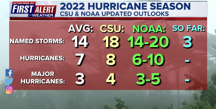
Updated Atlantic seasonal forecast from early Aug. - NOAA & CSU:
The East Pacific:
“Madeline” has formed over the far E. Pacific & will slowly peel away to the northwest then west staying mostly well offshore of Mexico though there will be some heavy rain & rough seas/surf on the Central Mexican west coast into Mon.


West Pacific:

Global tropical activity:


“Nanmadol” moved over Southern Japan Sunday & is weakening now while turning sharply northeast over much of the main island through Tue. - still producing strong winds & heavy rain.


Cox Media Group
:quality(70)/cloudfront-us-east-1.images.arcpublishing.com/cmg/HJ3L3HBBJBH6PB5ZFB3SVGFXSU.png)
:quality(70)/cloudfront-us-east-1.images.arcpublishing.com/cmg/4TQDXERT5VGORNZ4NQWXNO5H64.png)
:quality(70)/cloudfront-us-east-1.images.arcpublishing.com/cmg/SKX4RKW645ERTATCLA4V2FVRKQ.png)
:quality(70)/cloudfront-us-east-1.images.arcpublishing.com/cmg/5PIZRG7NYBAHDDABTG5BNVGO6Y.jpg)
:quality(70)/cloudfront-us-east-1.images.arcpublishing.com/cmg/V7JDMMD6JJEEHIL6C7OSLV3ABU.png)
:quality(70)/cloudfront-us-east-1.images.arcpublishing.com/cmg/EJ2WDI4TDXUSCBDQ2R7EJ2WIAQ.jpg)
:quality(70)/cloudfront-us-east-1.images.arcpublishing.com/cmg/HWTCKTZ7XVYRMPOSFR5JO4FJRM.jpg)
:quality(70)/cloudfront-us-east-1.images.arcpublishing.com/cmg/MQAGUPBIGKUTTHE2N2N5OTMMHU.jpg)
 Sign Up

