
Jacksonville, Fl. — The “Buresh Bottom Line”: Always be prepared!.....First Alert Hurricane Survival Guide... City of Jacksonville Preparedness Guide... Georgia Hurricane Guide.
STAY INFORMED: Get the * FREE * First Alert Weather app
FREE NEWS UPDATES, ALERTS: Action News Jax app for Apple | For Android
WATCH “Preparing for the Storm”
WATCH “The Ins & Outs of Hurricane Season”
READ the First Alert Hurricane Center “Survival Guide”
LISTEN & WATCH “Surviving the Storm” - WOKV Radio & Action News Jax
***** ALWAYS CHECK & RE-CHECK THE LATEST FORECAST & UPDATES! *****
REMEMBER WHEN A TROPICAL STORM OR HURRICANE IS APPROACHING: Taping windows is *NOT* helpful & will not keep glass from breaking.
Realize the forecast cone (”cone of uncertainty”) is the average forecast error over a given time - out to 5 days - & *does not* indicate the width of the storm &/or damage that might occur.

*** Very high rip current risk at NE Fl./SE Ga. area beaches through the week ahead... potential impacts from at least a tropical storm, possibly a hurricane by mid to late week... folks in or traveling to the Bahamas, Florida & east coast of the U.S. should stay up to date on the latest forecasts *** ....
The most anomalous (unusual/rare) part of this storm will be the potential for a strong tropical system at a rather far north latitude for this late in the season...
For Jacksonville/NE Fl./SE Ga. specifically (given *current* forecast of ‘98-L’):
* Strong onshore flow will continue & become even stronger through the week ahead with life threatening rip currents & dangerous overall marine conditions.
* Light to moderate beach erosion early in the week will become heavy to severe by mid to late week - a critical facet of the storm & conditions considering the recent damage from Ian
* Winds of 15-25 mph at the beaches early in the week will increase to 40+ mph - in gusts but possibly sustained - by mid to late week
* Rainfall will average 4-6″+ along the coast... 1-3″+ inland
* Flooding will be a daily threat at the beaches becoming more significant with each day through the upcoming week. There will also be an astronomical boost due to the full moon phase which begins Tue.
* If the storm gets far enough south & west, there will be a tornado & waterspout threat Wed. through Fri.
* Inland impacts are likely to be realized by mid to late week in the form of wind, rain, flooding & tornadoes BUT WILL BE DEPENDENT ON EXACT TRACK & STRENGTH OF THE STORM.
Low pressure - ‘98-L’ is just beginning to develop over the SW Atlantic about 100-200 miles north of Puerto Rico with a broad center gradually taking shape. Initially - given satellite data including a pronounced dry slot from the southwest wrapping into the center + some probably frontal features - the low may be hybrid or subtropical in nature but should eventually transition to a purely tropical system within a relatively short time given the warm water & the lack of an upper level trough as an upper ridge builds near & north of the storm. Nicole is next on the list of names followed by Owen (it’s possible that ‘97-L’ over the Central Atlantic will be upgraded first). This will be a long process: slow to develop... may begin as nontropical or subtropical before becoming purely tropical... will move erratically but in a general west or southwest direction once established (deeper/stronger).
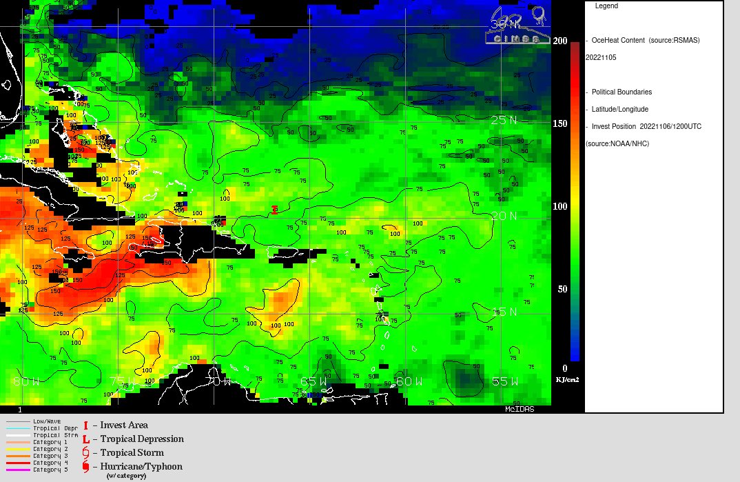
Most concerning is that conditions appear rather optimal for strengthening once ‘98-L’ starts moving west. Shear will be decreasing, moisture increasing & sea surface temps. are warm including pretty significant deep oceanic heat content (warm water to a deep depth).
Global forecast models have been trending toward rather remarkable agreement (for a storm in its infancy & still days away from becoming better organized) with the low moving west/southwest... hitting South & Southeast Florida... then as far west as the Eastern Gulf or Fl. west coast... before feeling the effects of a strong upper level trough that will then finally pick up the storm & steer it north & northeast while accelerating. It is quite possible this will attain hurricane strength over or near the Bahamas & *could* hit S/SE Fl. as a hurricane. Impacts are expected for all of Fl. except *probably* for most of the Panhandle... in addition to the Bahamas + parts of the Carolina’s to perhaps as far north as Chesapeake Bay in the longer term.
One thing for sure: there will be an extended period - 5+ days - of strong to very strong onshore flow... rough seas & surf with double digit breakers at the beaches... gusty & - at times - strong winds... rain, heavy at times. It appears *at this time* that the peak of these impacts will be from Tue. through Sat. The exact details remain fuzzy & very much in flux & there will be some changes to the forecast as to the exact extent & timing of impacts but there will undoubtedly be significant impacts on at least the east coast from Florida to the Carolina’s.
Stay up to date across all of Fl. & much of the Southeast U.S. coast, Puerto Rico, Virgin Islands, Hispaniola & Cuba.


Spaghetti plots for ‘98-L’ - this will populate with more models as the system becomes better developed:

Spaghetti plots for ‘97-L’:


Let’s do some “examinin’”:
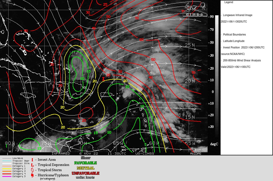
Shear is currently strong across most of the SW Atlantic with speeds of 30+ mph. However, the upper level atmosphere will be undergoing some significant changes over the next 5 days that will include less shear & a building upper level ridge to the north of the low. At the same time, a strong upper level trough will be digging into the Central U.S. & eventually into the Eastern U.S. This strong trough will be critical to the eventual movement - including curvature to the north/northeast - & intensity of the storm. The added upper level ventilation from the trough may aid in intensifying the storm... or at least maintaining the storm as it eventually accelerates to the northeast. Following this trough, there will be a serious invasion of cold air across the Lower 48 as the tropical system seems to be a catalyst for a pattern flip reminiscent of “Wilma” in 2005 which hit Fl. Oct. 24th & was followed/guided by a deep trough moving across the Lower 48.
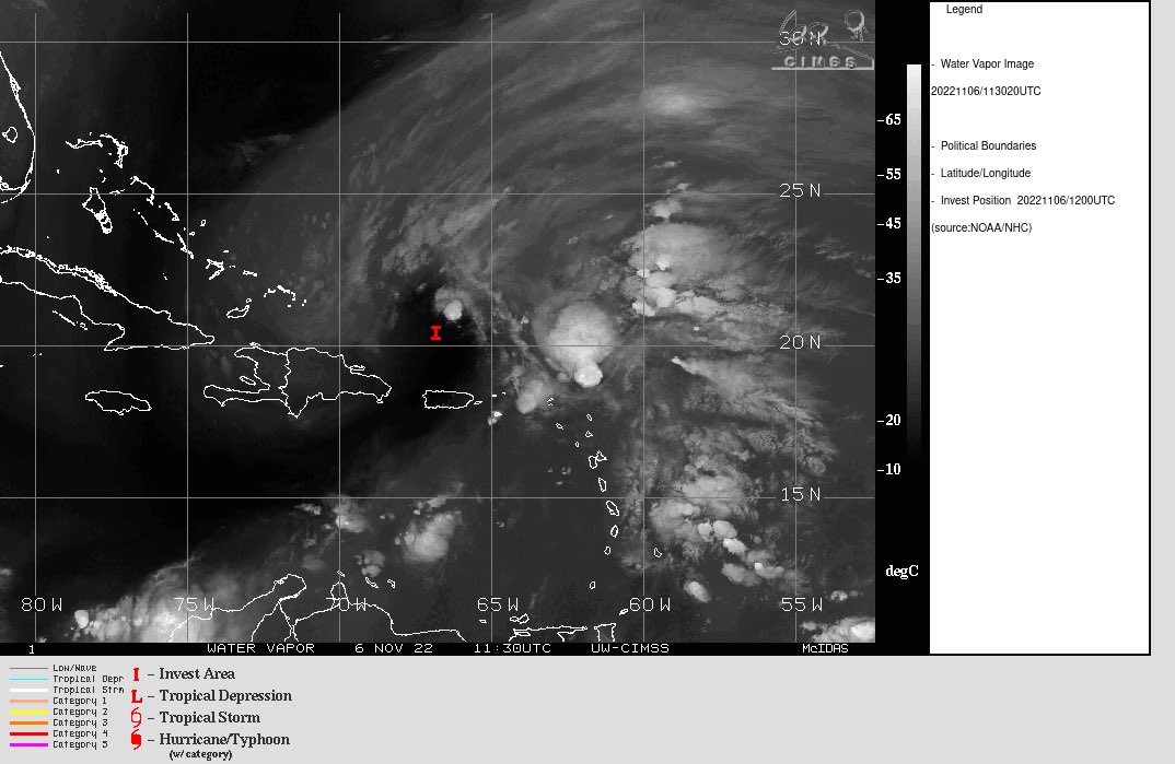


Water vapor loop shows pockets of dry air (dark blue) across portions of the Atlantic Basin along with a lot of “swirls” (low pressure) along with “bands” of higher moisture near & ahead of fronts - common as we get deeper into autumn. ‘98-L’ will be battling a good deal of dry air until at least midweek.

Radar imagery courtesy S. Florida Water Management District:


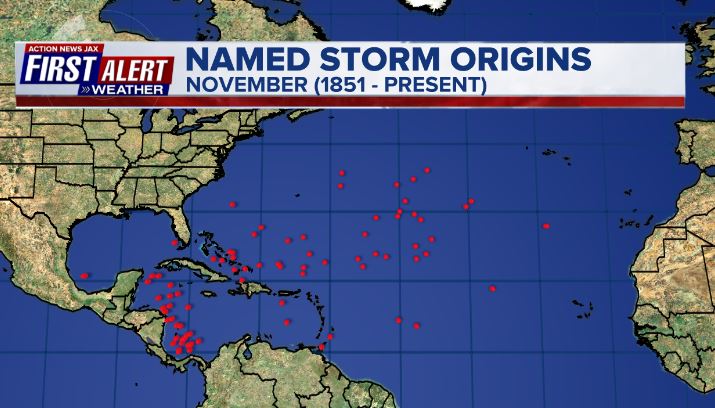
November tropical cyclone origins:
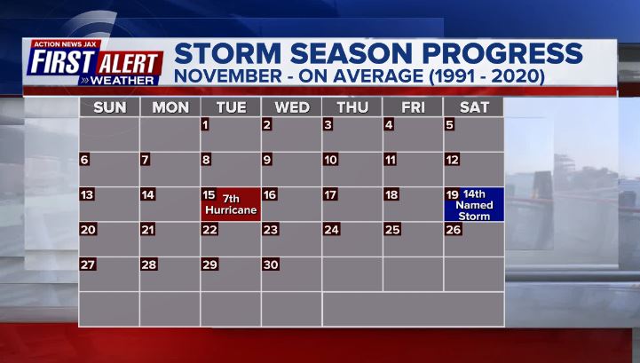
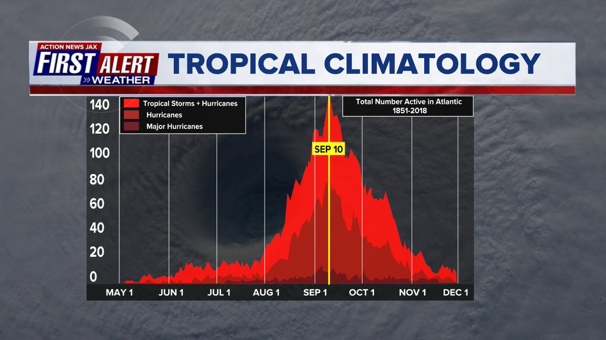
Averages below based on climatology for the Atlantic Basin through November:
Wind shear:


Saharan dust spreads west each year from Africa by the prevailing winds (from east to west over the Atlantic). Dry air - yellow/orange/red/pink. Widespread dust is indicative of dry air that can impede the development of tropical cyclones. However, sometimes “wanna’ be” waves will just wait until they get to the other side of - or away from - the plume then try to develop if other conditions are favorable. In my personal opinion, way too much is made about the presence of Saharan dust & how it relates to tropical cyclones. In any case, we’ve had several large dust plumes spread west to the Caribbean & Gulf with the peak of Saharan dust typically in June & July.

2022 names..... “Nicole” is the next name on the Atlantic list (names are picked at random by the World Meteorological Organization... repeat every 6 years). Historic storms are retired [Florence & Michael in ’18... Dorian in ’19 & Laura, Eta & Iota in ‘20 & Ida in ‘21]). In fact, this year’s list of names is rather infamous with “Charley”, “Frances”, “Jeanne” & “Ivan” retired from the ‘04 list (all hit Fl.) & “Matthew” was retired in 2016. The WMO decided - beginning last year - that the Greek alphabet will be no longer used & instead there will be a supplemental list of names if the first list is exhausted (has only happened three times - 2005, 2020 & 2021). The naming of tropical cyclones began on a consistent basis in 1953. More on the history of naming tropical cyclones * here *.


East Atlantic:


Mid & upper level wind shear (enemy of tropical cyclones) analysis (CIMMS). The red lines indicate strong shear:

Water vapor imagery (dark blue indicates dry air):

Deep oceanic heat content over the Gulf, Caribbean & deep tropical Atlantic:

Sea surface temp. anomalies:


SE U.S. surface map:

Surface analysis centered on the tropical Atlantic:

Surface analysis of the Gulf:

Caribbean:

GFS wave forecast at 48 & 72 hours (2 & 3 days):


Atlantic Basin wave period forecast for 24, 48 & 72 hours respectively:


The East Pacific:


West Pacific:

Global tropical activity:


Cox Media Group


 Sign Up


