
Jacksonville, Fl. — The “Buresh Bottom Line”: Always be prepared!.....First Alert Hurricane Survival Guide... City of Jacksonville Preparedness Guide... Georgia Hurricane Guide.
STAY INFORMED: Get the * FREE * First Alert Weather app
FREE NEWS UPDATES, ALERTS: Action News Jax app for Apple | For Android
WATCH “The Ins & Outs of Hurricane Season”
WATCH “Preparing for the Storm”
READ the First Alert Hurricane Center “Survival Guide”
***** ALWAYS CHECK & RE-CHECK THE LATEST FORECAST & UPDATES! *****
REMEMBER WHEN A TROPICAL STORM OR HURRICANE IS APPROACHING: Taping windows is *NOT* helpful & will not keep glass from breaking... & realize the cone is the average forecast error over a given time - out to 5 days - & *does not* indicate the width of the storm &/or damage therefore do not become fixated on the center of a tropical system.

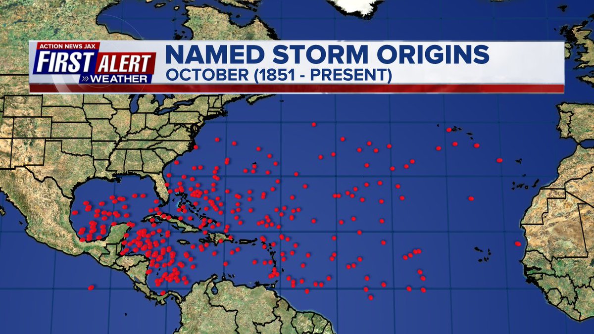
October origins for tropical cyclones:
According to Dr. Phil Klotzbach, Victor - the 8th named storm in Sept. - 2021 now joins 2002, 2007, 2010 & 2020 as the only years with 8+ named storms developing during the month. And only last year had more total named storms - 23 - by Sept. 29th.
“Sam”:
The strong tropical wave - ‘98-L’ - was upgraded Wed. afternoon to tropical depression #18 then to tropical storm “Sam” Thursday morning & to a hurricane early Friday (avg. date for the 7th Atlantic hurricane is Nov. 16), so Sam has been a hurricane for a week plus. Sam was a compact/intense storm but has been “spreading its wings” recently & has essentially been steady state. A NOAA buoy early Thu. measured 40 foot seas within the northeast quadrant of the hurricane! Though staying far to the east, an easterly swell & heightened rip current risk will affect much of the eastern U.S. seaboard through the weekend, including NE Fl./SE Ga. Bermuda was spared a direct hit as the core of Sam moved well east of the island Fri. night.
The steering pattern remains well established as the hurricane finally reaches the N. Atlantic Sunday into Monday at which time Sam will become a large & strong extra-tropical ocean storm.
Ultimately... the end result - Sams’ track - was driven by September’s re-adjustment of the upper level flow across the Northern Hemisphere which includes a pretty persistent trough the last several weeks over & near the Eastern U.S. & Western Atlantic. If the trough stays, the U.S. eastern seaboard is protected.
“Victor”:
A strong tropical wave that moved off the coast of Africa Tue. was upgraded to tropical depression #20 Wed. morning & to “Victor” Wed. afternoon. The good news: - thanks to the Bermuda High sitting so far to the north & east over the Atlantic - Victor turned sharply northward as it rapidly organized. Victor will stay far to the east over the open Atlantic & weaken as shear is strong out of the south & southwest.
Long range forecast models are showing the potential for some low pressure to develop over the Western/SW Atlantic next week. We’ll have to watch this for possible tropical characteristics.... in addition to - perhaps - parts of the Caribbean.

(Skinny cone means high forecast uncertainty):


Notice Sam is west of a good deal of African Saharan dust (brown/gray area on the satellite below) while Victor is firmly within the cloud of dust (once again - the dust is way over-played in some weather “schools”):


Sam spaghetti plots:


Victor:


An unfavorable MJO phase has generally helped keep recent Atlantic tropical cyclones mostly “in check”. There is a lot of “sinking” (brown lines) air over the Atlantic Basin which doesn’t usually favor a good deal of tropical development (there can be exceptions!). *But* the rising air (green lines) will likely overspread the Atlantic as we move through Oct. leading to a potentially active 2nd to the last month of the Atlantic hurricane season. During this evolution, we’ll need to monitor the Caribbean, Gulf of Mexico & SW Atlantic where we’re already getting some occasional - albeit inconsistent - hints from long range models of tropical development.

The potential development over the E. Pacific is likely a product of the MJO pulse:

Ocean temps. remain “fit” to help maintain tropical cyclones.
Sea surface temps. across the Atlantic are now near to above avg. across much of the basin (2nd image below) & - even more importantly - deep oceanic heat content (which helped “feed” Ida) is impressive & the “equivalent oceanic heat content” - namely depth averaged temperature in the upper 300 m (~984 feet) - is even more impressive all the way from Africa to the Gulf of Mexico. Such an ocean water temp. pattern is conducive to long track deep tropical Atlantic tropical cyclones & can lead to a more favored regime for rapid intensification cycles. From an AMS research paper in ‘08 Mainelli, DeMaria, Shay, Goni: “Results show that for a large sample of Atlantic storms, the OHC variations have a small but positive impact on the intensity forecasts. However, for intense storms, the effect of the OHC is much more significant, suggestive of its importance on rapid intensification. The OHC input improved the average intensity errors of the SHIPS forecasts by up to 5% for all cases from the category 5 storms, and up to 20% for individual storms, with the maximum improvement for the 72–96-h forecasts. The statistical results obtained indicate that the OHC only becomes important when it has values much larger than that required to support a tropical cyclone.” More recent research continues to indicate similar correlations.


Saharan dust. Dry air - yellow/orange/red/pink. Widespread dust is indicative of dry air that can impede the development of tropical cyclones. However, sometimes “wanna’ be” waves will just wait until they get to the other side of the plume then try to develop if everything else happens to be favorable. In my personal opinion, way too much is made about the presence of Saharan dust & how it relates to tropical cyclones.

2021 names..... “Wanda” is the next & last name on the Atlantic list (names are picked at random by the World Meteorological Organization... repeat every 6 years... historic storms are retired (Florence & Michael in ’18... Dorian in ’19 & Laura, Eta & Iota in ‘20). Last year - 2020 - had a record 30 named storms. The WMO decided beginning this year that the Greek alphabet will be no longer used & instead there will be a supplemental list of names if the first list is exhausted (has only happened twice - 2005 & 2020). More on the history of naming tropical cyclones * here *.


East Atlantic:


Mid & upper level wind shear (enemy of tropical cyclones) analysis (CIMMS). The red lines indicate strong shear:

Water vapor imagery (dark blue indicates dry air):

Deep oceanic heat content continues to increase across the Gulf, Caribbean & deep tropical Atlantic & has become pretty impressive from the Central/NW Caribbean into the Gulf of Mexico:

Sea surface temp. anomalies:

SE U.S. surface map:

Surface analysis centered on the tropical Atlantic:

Surface analysis of the Gulf:

Caribbean:

GFS wave forecast at 48 & 72 hours (2 & 3 days):


Atlantic Basin wave period forecast for 24, 48 & 72 hours respectively:


The East Pacific:
The eastern North Pacific (ENP; to 180°) has had only 1 named storm form (Olaf) this month, and no tropical cyclones are anticipated in next 5 days per NHC. Accordiing to Klotzbach: “Only 5 Septembers since 1970 have had just 1 ENP named storm form: 1971, 1974, 1979, 2020, 2011″.


West Pacific IR satellite:
“Mindulle” has made the sharp turn north & northeast over the open W. Pacific which was a helpful hint with “Sam” over the Central Atlantic (typhoon teleconnection with a persistent trough near the east coast of China mirroring the trough near the Eastern U.S.) In other words, Sam turning more north vs. a more west movement which was originally a “miss” by the European model.


Global tropical activity:


Cox Media Group


 Sign Up


