:quality(70)/cloudfront-us-east-1.images.arcpublishing.com/cmg/WW5AJL3ARQUGDQMAQUNSFX4CLE.jpg)
Jacksonville, Fl. — The “Buresh Bottom Line”: Always be prepared!.....First Alert Hurricane Survival Guide... City of Jacksonville Preparedness Guide... Georgia Hurricane Guide.
STAY INFORMED: Get the * FREE * First Alert Weather app
FREE NEWS UPDATES, ALERTS: Action News Jax app for Apple | For Android
WATCH “Talking & Tracking the Tropics: The Science Behind the Season”
WATCH “Preparing for the Storm”
READ the First Alert Hurricane Center “Survival Guide”
***** ALWAYS CHECK & RE-CHECK THE LATEST FORECAST & UPDATES! *****
*** SALLY WILL NOT HAVE DIRECT IMPACTS ON JACKSONVILLE/NE FL./SE GA. THROUGH TUE. BUT MAY DROP SOME HEAVY RAIN LATER IN THE WEEK ***
TROPICS:
(1) an area of ‘disturbed’ weather (showers & storms) that developed over the Bahamas late last week was upgraded to tropical depression #19 Fri. making landfall on the southeast coast of Fl. not far from Miami about 2am EDT Sat. then re-emerged over the warm Gulf by midday Sat. then quickly became tropical storm “Sally” Sat. afternoon. Like most of the names this season... this is the fastest to 'S’ beating the record of “Stan” Oct. 2, 2005. Sally has remained steady state while looking a little raged on satellite imagery. In general, however, conditions looks to be favorable for at least gradual intensification just about right up to landfall. Sally will turn more to the west/ northwest then northwest up to landfall by Tuesday along the Louisiana or Mississippi coast. Bursts of t’storms may cause the center to jump around some until - & unless - a decent core develops.
Models were having a difficult time “finding” the depression but now that the tropical cyclone is stronger, the models are much better in their initialization. Special N.W.S. balloon soundings - 4 a day vs. the normal 2 per day - will be released for at least the next several across the Gulf Coast & Southeast U.S. in an attempt to have better analysis data for the models which would then translate into better output (forecasts). Right now it looks like a steady west/northwest to northwest move through Mon. night. Upon approach to the Gulf Coast Mon. night into Tue., the upper level ridge becomes rather soft with westerlies - albeit rather weak - extending south to near the Gulf Coast. How this set-up evolves will be critical as to where exactly Sally - forecast right now to be a Cat. 1 hurricane - comes ashore & where it moves thereafter. It appears there will be a slow turn to the northeast after landfall resulting in very heavy rainfall on the order of at least 1-2 feet! The GFS model is very near New Orleans... the European is a little more to the west... the UKMET is more to the east. It looks like Sally will then move slowly east/northeast with the remnants reaching Georgia by Thu/Fri. likely still producing heavy rain in its vicinity. Some of this rain could occur over NE Fl./SE Ga.
Everyone along the Gulf Coast - especially from the Fl. Panhandle to Louisiana - needs to stay up to date on the latest forecasts.


(2) Tropical depression #17 formed over the Eastern Atlantic Sunday & was upgraded to tropical storm “Paulette” Mon. The fastest ever to ’P’ easily beating the old record of Philippe Sept. 17, 2005. Paulette seems to have finally found that “sweet spot” & is becoming more organized & stronger. The forecast is for Paulette to continue the northward turn then sharply to the northeast through the upcoming week. Paulette will be an “ocean storm” staying well east of the U.S. *but* moved over Bermuda early Mon. with the entire island enveloped by the eye near 5am EDT.
Though far to the east, easterly swells & an increasing rip current risk affect Florida & much of the Eastern U.S. coast this week as Paulette strengthens into a Cat. 3+ hurricane.
(3) Depression #20 formed Sat. from a westbound African tropical wave & was upgraded to “Teddy” early Mon.
This is the fastest to the 20th storm breaking the record of an unnamed tropical storm Oct. 4, 2005. Indications are that the Bermuda High to the north will shift more to the east & north allowing for a turn to the north over the Western Atlantic. But the steering flow is by no means locked in yet once into the Central Atlantic. This will be a clear miss for the Antilles.... & likely stays far to the east of the U.S.

(4) Tropical depression #18 was upgraded just off the coast of Africa early Mon. then to tropical storm “Rene” Mon. afternoon before a weakening trend Tue. night followed by another strengthening trend Thu. Rene is now again struggling thanks to nearby dry air & shear. Rene should turn more west in the long run as the storm weakens & becomes more shallow & eventually dissipates.
(5) Another African tropical wave was upgraded just off the coast of Africa early Mon. to tropical depression #21. While there is a short window of “opportunity” to strengthen, t.d. #20 will stay over the far Eastern Atlantic & is forecast to dissipate by about midweek.
Yet another African tropical wave will move off the coast later this week.
(6) A lowering of pressures has been indicated by forecast models over the Western Gulf of Mexico into next week. Low pressure may eventually develop... or there could be some interaction with other waves/disturbances. If so, it’s an area to keep an eye on for possible tropical development.


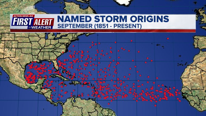
September is usually the most active month of the hurricane season:


:quality(70)/cloudfront-us-east-1.images.arcpublishing.com/cmg/HJ3L3HBBJBH6PB5ZFB3SVGFXSU.png)
:quality(70)/cloudfront-us-east-1.images.arcpublishing.com/cmg/4TQDXERT5VGORNZ4NQWXNO5H64.png)
:quality(70)/cloudfront-us-east-1.images.arcpublishing.com/cmg/SKX4RKW645ERTATCLA4V2FVRKQ.png)
:quality(70)/cloudfront-us-east-1.images.arcpublishing.com/cmg/5PIZRG7NYBAHDDABTG5BNVGO6Y.jpg)
:quality(70)/cloudfront-us-east-1.images.arcpublishing.com/cmg/V7JDMMD6JJEEHIL6C7OSLV3ABU.png)
:quality(70)/cloudfront-us-east-1.images.arcpublishing.com/cmg/J4UB75NRRDOML5ZMUZI7QJDELI.jpg)
:quality(70)/cloudfront-us-east-1.images.arcpublishing.com/cmg/W4FYR7IDFLLTCJFDSEAWGKJ7OE.jpg)
:quality(70)/cloudfront-us-east-1.images.arcpublishing.com/cmg/MUBZAZTYFEUO6EKDNQ5CI35P4E.jpg)
 Sign Up

