:quality(70)/cloudfront-us-east-1.images.arcpublishing.com/cmg/WW5AJL3ARQUGDQMAQUNSFX4CLE.jpg)
Jacksonville, Fl. — The “Buresh Bottom Line”: Always be prepared!.....First Alert Hurricane Survival Guide... City of Jacksonville Preparedness Guide... Georgia Hurricane Guide.
STAY INFORMED: Get the * FREE * First Alert Weather app
FREE NEWS UPDATES, ALERTS: Action News Jax app for Apple | For Android
WATCH “The Ins & Outs of Hurricane Season”
WATCH “Preparing for the Storm”
READ the First Alert Hurricane Center “Survival Guide”
***** ALWAYS CHECK & RE-CHECK THE LATEST FORECAST & UPDATES! *****
Impacts on Jacksonville/NE Fl./SE Ga. from disturbance ‘92-L’:
* virtually none
* as the remnant low passes to the north & west by Sunday into Monday, tropical moisture will surge to the northeast across the local area resulting in an uptick in showers & t’storms & heavy rainfall.
* if traveling west on I-10 through the weekend.... & eventually north on I-75, be prepared for heavy rain & areas of flooding.
Disturbed weather - lots of of disorganized convection - continues over the Southwest Gulf & near & over Central America. The low pressure area has nudged slightly north & east to over the Bay of Campeche. There will still be some interference from land through Thu. but the low will move over the open W. Gulf by early Fri. allowing for some gradual development. Much of the strongest & heaviest convection (t’storms & rain) are to the east of the low & this pattern will likely continue through the weekend - a system heavily weighted on its eastern side. Such a hybrid or subtropical-looking system is common early in the hurricane season. Overall, there’s not a lot of change to the thinking & forecast in what will likely become at least a tropical depression & possibly a tropical/subtropical storm by late Fri./Fri. night. All indictions are that this system will not be overly intense but will be an efficient rain-producer so flooding is the primary concern.
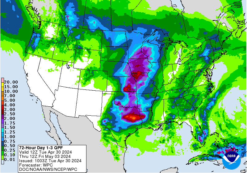
A Friday night/early Saturday landfall on or near the Louisiana coast, is most likely - west of New Orleans. While winds won’t be particularly strong (as tropical systems go), there will be a lot of rain + the threat for isolated tornadoes & waterspouts from the upper Texas coast east across especially Louisiana to Mississippi & Alabama. If the system can remain organized long enough - & it appears this is a possibility - heavy rain & isolated tornadoes may continue into the weekend & early next week along & near the track of the low well into Alabama, Georgia & possibly the Carolina’s. Rainfall forecast maps show a “blob” of heavy rain along the Gulf coast nosing northward & well inland with more than a half a foot of rain possible from near New Orleans east to the Western Florida Panhandle:

While not as active as earlier this week, a few tropical waves continue to move west across the deep tropical Atlantic:

Spaghetti model plots for ‘Invest 92′:


Saharan dust. Dry air - yellow/orange/red/pink - is extensive over especially the Central Atlantic. Such widespread dust is common early in the hurricane season:

2021 names..... “Claudette” is the next name on the Atlantic list (names are picked at random by the World Meteorological Organization... repeat every 6 years... historic storms are retired (Florence & Michael in ’18... Dorian in ’19 & Laura, Eta & Iota in ‘20). Last year - 2020 - had a record 30 named storms. The WMO decided beginning in 2021 that the Greek alphabet will be no longer used & instead there will be a supplemental list of names if the first list is exhausted (has only happened twice - 2005 & 2020). More on the history of naming tropical cyclones * here *.


East Atlantic:


Mid & upper level wind shear (enemy of tropical cyclones) analysis (CIMMS). The red lines indicate strong shear which is widespread from the Gulf of Mexico & Caribbean eastward across much of the Atlantic:

Water vapor imagery (dark blue indicates dry air):

Deep oceanic heat content is slowly increasing across the SE Gulf, Caribbean & deep tropical Atlantic:

Sea surface temp. anomalies:


SE U.S. surface map:

Surface analysis centered on the tropical Atlantic:

Surface analysis of the Gulf:

Caribbean:

Atlantic Basin wave forecast for 24, 48 & 72 hours respectively:


Global tropical activity:


Cox Media Group
:quality(70)/cloudfront-us-east-1.images.arcpublishing.com/cmg/HJ3L3HBBJBH6PB5ZFB3SVGFXSU.png)
:quality(70)/cloudfront-us-east-1.images.arcpublishing.com/cmg/4TQDXERT5VGORNZ4NQWXNO5H64.png)
:quality(70)/cloudfront-us-east-1.images.arcpublishing.com/cmg/SKX4RKW645ERTATCLA4V2FVRKQ.png)
:quality(70)/cloudfront-us-east-1.images.arcpublishing.com/cmg/5PIZRG7NYBAHDDABTG5BNVGO6Y.jpg)
:quality(70)/cloudfront-us-east-1.images.arcpublishing.com/cmg/V7JDMMD6JJEEHIL6C7OSLV3ABU.png)
:quality(70)/cloudfront-us-east-1.images.arcpublishing.com/cmg/J4UB75NRRDOML5ZMUZI7QJDELI.jpg)
:quality(70)/cloudfront-us-east-1.images.arcpublishing.com/cmg/RZ7QALUZKWJE2CXMTEPOGZKS6I.jpg)
 Sign Up

