Jacksonville, Fl. — The “Buresh Bottom Line”: Always be prepared!.....First Alert Hurricane Preparation Guide... City of Jacksonville Preparedness Guide... Georgia Hurricane Guide.
STAY INFORMED: Get the * FREE * First Alert Weather app
FREE NEWS UPDATES, ALERTS: Action News Jax app for Apple | For Android
WATCH “Preparing for the Storm”
WATCH “The Ins & Outs of Hurricane Season”
READ the First Alert Hurricane Center “Survival Guide”
LISTEN & WATCH “Surviving the Storm” - WOKV Radio & Action News Jax
***** ALWAYS CHECK & RE-CHECK THE LATEST FORECAST & UPDATES! *****
REMEMBER WHEN A TROPICAL STORM OR HURRICANE IS APPROACHING: Taping windows is *not* recommended & will not keep glass from breaking. Instead close curtains & blinds.
Realize the forecast cone (”cone of uncertainty”) is the average forecast error over a given time - out to 5 days - & *does not* indicate the width of the storm &/or where damage that might occur.

In the SW Atlantic.... A lead tropical wave - ‘95-L’ is approaching the Caribbean & is producing heavy but disorganized showers & t’storms. Conditions become even more hostile in the coming days over the Caribbean, so no significant development is likely to occur. Some gusty squalls will occur over the Windward Islands through Wed. Taking all things into consideration, 95-L should struggle while moving westward over the Caribbean Sea. Image below is a zoomed-in version of the Caribbean shear greater than 35-45 mph!:
There is a weak surface trough in tandem with an “upper tropospheric trough” (TUTT) over the Central Atlantic well to the south & southwest of Bermuda. The NHC has found it prudent to show a yellow (low chance) area for possible development going right up to the coast of Fl../Ga./S. Carolina. This has really set off the alarm bells for some, especially on social media. Folks - this does not look to be a significant problem/disturbance. The trough will push west/northwest around the edge of the Bermuda High located over the Central/E. Atlantic reaching Fl. Thu. night-Fri. night. There will be some uptick in showers & t’storms on the east side of the disturbance.
Meanwhile... A distant trailing wave coming off the coast of Africa seems to have a higher chance for more significant development - at a higher (more north) latitude - mainly sometime next week. The GFS model is particularly robust, but that’s a problem so far this season with longer range output. The European forecast model is a little slower & a little weaker... at this point.


Velocity potential anomalies as shown below show a favorable state (green lines indicating “rising” air) over a good part of the Pacific. Some of this more favorable area will likely migrate eastward over parts of the Atlantic Basin over the next couple weeks leading to some potential Atlantic development.


Water vapor loop (dark blue/yellow is dry mid & upper level air):


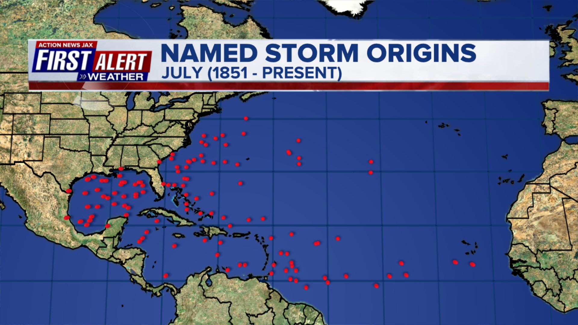
July tropical cyclone origins:
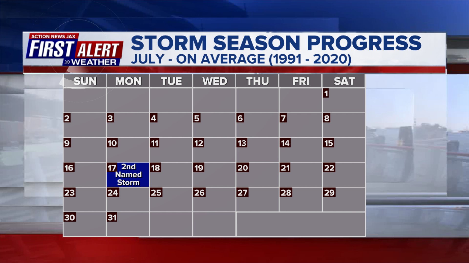
Averages below based on climatology for the Atlantic Basin for July (already at 3 named storms):

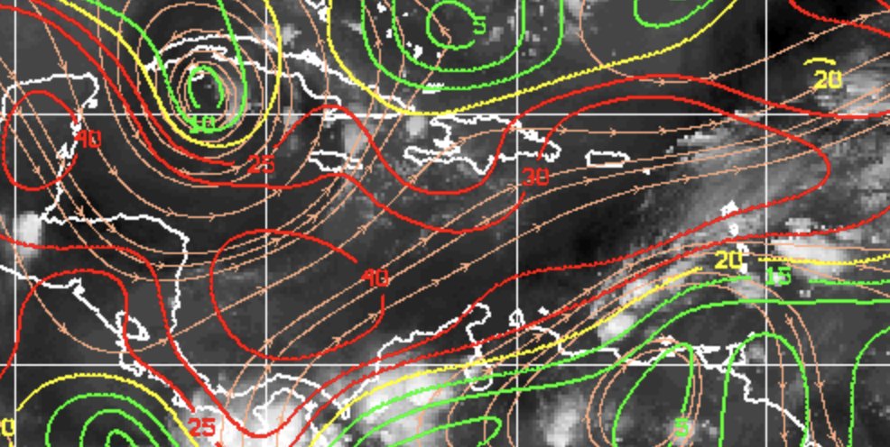
Wind shear:


Saharan dust spreads west each year from Africa by the prevailing winds (from east to west over the Atlantic). Dry air - yellow/orange/red/pink. Widespread dust is indicative of dry air that can impede the development of tropical cyclones. However, sometimes “wanna’ be” waves will just wait until they get to the other side of - or away from - the plume then try to develop if other conditions are favorable. In my personal opinion, way too much is made about the presence of Saharan dust & how it relates to tropical cyclones. In any case, the peak of Saharan dust typically is in June & July.

2023 names..... “Emily” is the next name on the Atlantic list (names are picked at random by the World Meteorological Organization... repeat every 6 years). Historic storms are retired [Florence & Michael in ’18... Dorian in ’19 & Laura, Eta & Iota in ‘20, Ida in ‘21 & Fiona & Ian in ‘22]). In fact, this year’s list of names is rather infamous with “Katrina”, “Rita” & “Wilma” retired from the ‘05 list & “Harvey”, “Irma”,“Maria” & “Nate” from the ‘17 list. The WMO decided - beginning in 2021 - that the Greek alphabet will be no longer used & instead there will be a supplemental list of names if the first list is exhausted (has only happened three times - 2005, 2020 & 2021). The naming of tropical cyclones began on a consistent basis in 1953. More on the history of naming tropical cyclones * here *.


East Atlantic:


Mid & upper level wind shear (enemy of tropical cyclones) analysis (CIMMS). The red lines indicate strong shear:

Water vapor imagery (dark blue indicates dry air):

Deep oceanic heat content over the Gulf, Caribbean & deep tropical Atlantic. The brighter colors will expand rather dramatically by Aug./Sept./Oct.:

Sea surface temp. anomalies:


SE U.S. surface map:

Surface analysis centered on the tropical Atlantic:

Surface analysis of the Gulf:

Caribbean:

GFS wave forecast at 48 & 72 hours (2 & 3 days):


Atlantic Basin wave period forecast for 24, 48 & 72 hours respectively:


East/Central Pacific:


West Pacific:

Global tropical activity:

“Doksuri” will impact the Northern Philippines & Taiwan the next couple days before a China landfall by late week:


Cox Media Group